
Nearly 1 million Attwater’s greater prairie-chickens (Tympanuchus cupido attwateri) once occupied 6 million acres of coastal prairie grasslands in Texas and Louisiana. Loss and fragmentation of habitat nearly drove this species to extinction, and it was listed as endangered in 1967. Today, two populations have been established in the wild through release of captive-reared birds.
This project identified areas of potential habitat throughout the historical range for consideration as additional release sites. Woody vegetation encroachment was assessed using the 2016 National Land Cover Database derived from Landsat imagery and the 2019 Global Forest Canopy Height layer derived from NASA Global Ecosystem Dynamics Investigation (GEDI) satellite-based lidar.
The probability of use of grassland habitat by greater prairie-chickens for annual mating rituals (“booming grounds”) and nest sites declines sharply as tree canopy cover exceeds 2%. Based on this knowledge, potential habitat was delineated as shrub/scrub, herbaceous, or hay/pasture and having less than 2% canopy cover taller than 3 m within 1 km. The largest patch of this potential high-quality habitat consisted of 41,877 acres within Goliad County, Texas. Additional large patches meeting the criteria were located in Texas north of Anahuac National Wildlife Refuge (30,030 acres) and west of the Whitmire Unit of Aransas National Wildlife Refuge (16,632 acres). This assessment reaffirmed that Goliad County retains the greatest extent of potential high-quality habitat and provided a map of additional areas to evaluate for use as future release sites.
https://ecos.fws.gov/docs/tess/species_nonpublish/995.pdf
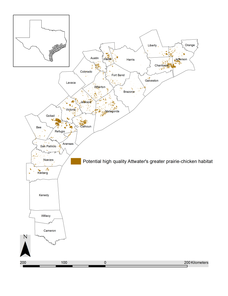
Potential high-quality habitat for the endangered Attwater's prairie-chicken on the Texas Gulf Coastal Plain.