
Sea level rise inundation on important Department of Interior (DOI) conservation lands was estimated using U.S. Geological Survey (USGS) 3D Elevation Program (3DEP) high-resolution light detection and ranging (lidar) data coupled with National Oceanic and Atmospheric Administration (NOAA) models. Projections for DOI lands were made from all the Global Sea Level Rise models and time steps from 2000 to 2100 to assist in climate resiliency planning.
Raster data layers that depict water extent for relative sea level rise (RSLR) amounts of 0.3-meter, 0.5-meter, 1.0-meter, 1.5-meter, 2.0-meter, and 2.5-meter for 10-year increments from 2000 to 2100 at 100-meter resolution were modeled in a GIS environment using elevation data from 3DEP lidar point cloud data, NOAA Relative Sea Level Rise grid point data (RSLR, derived from the Global Sea Level Rise models), and NOAA Mean Higher High Water (MHHW) conversion layers. These data layers were then intersected with a 1.524-meter resolution DEM data layer for the entire coast of North Carolina and the portions of Virginia connected to the estuaries of North Carolina and the resulting inundation areas were classified by connection or disconnection to the ocean.
The inundation data layers were intersected with fee title FWS lands, National Wetlands Inventory (NWI) Wetlands, Protected Areas Database of the United States (PAD-US) Conservation Lands as well as additional habitats of species of interest to FWS for timing, extent, and type (connected or disconnected) of inundation impacts.
Results can be used by DOI resource managers and partners to understand timing and areal extent of projected sea level rise and assist in coastal climate change resilience planning.
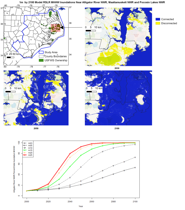
Study area for sea level rise modeling with blowup area of impacts of 1- meter relative sea level rise (RSLR) by the year 2100 to 3 US Fish and Wildlife Survey (FWS) National Wildlife Refuges (NWR). Plot indicates the timing and areal percentage of Alligator River NWR inundated at Mean Higher High Water (MHHW) under each of the 6 RSLR models.