
Large-scale investigations into land-use/land-cover change (LULCC) often rely on repeatable image classification processes. The process of labeling images as one of several classes can range from human-intensive manual interpretations to trained supervised classifications to computer-led unsupervised classifications. Machine learning (ML) has recently arisen as viable way to create models to accurately classify images derived from aerial and satellite platforms. The one caveat in any successful ML process is that ML is highly dependent on quality training data.
The Patterns in the Landscape – Analyses of Cause and Effect (PLACE) project is actively working toward applying ML to improve its LULCC mapping procedures. The project is beginning ML development focused on a use case of mapping water and wetland. To meet this goal, the project team is evaluating a range of possible training data, including surface water inundation maps generated by PLACE, wetland maps generated by the USFWS National Wetland Inventory, and legacy LULC information hand-interpreted by experts who worked on the USGS Land Cover Trends project. Testing a variety of existing geospatial data as possible training data is intended to help the team identify whether legacy data represent a viable alternative to creating training data from scratch. Training data are being fed into image classification models set up in Amazon SageMaker (in Amazon Web Services) with help from USGS Cloud Hosting Solutions. A second approach using open-source convolutional neural network software is also being tested. The team is currently tuning hyperparameters and analyzing model outputs prior to a wider implementation.
https://www.usgs.gov/centers/wgsc/science/patterns-landscape-analyses-cause-and-effect
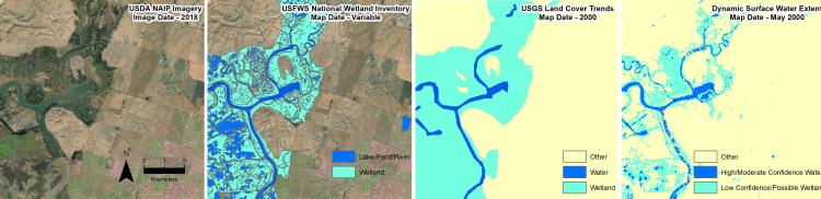
A wide range of existing water and wetland maps exist, including wetland maps from USFWS National Wetland Inventory, hand-classified LULC maps from USGS Land Cover Trends, and Dynamic Surface Water Extent maps generated by PLACE. The location of these maps is just southeast of Fairfield, California.