
Drought-related tree mortality events, in which large numbers of trees die suddenly and often unexpectedly, appear to be occurring more frequently worldwide. Such events can have substantial impacts on forests and increase the risk of catastrophic fires. Managers have tools available to try to increase the resilience of their forests against such events, including thinning through both mechanical means and prescribed fires. However, relatively few landscape-scale studies assess the effectiveness of these treatments during extreme drought. The recent very severe drought in California provided an opportunity to do just such a test.
USGS scientists are combining data from thousands of ground-based plots across the southern and central Sierra Nevada with Landsat-derived remote sensing indices to quantify the relationship between tree mortality during the drought and underlying forest structure and treatment history. The first step in this process is to test how well changes in remote sensing indices relate to actual tree mortality. Long-term plot data from Sequoia National Park and Yosemite National Park are being used to develop models that show a strong relationship between remote sensing metrics and mortality and to identify when those metrics are less reliable. The next step will be to use these models across the entire network of plots to develop an assessment of treatment effectiveness.
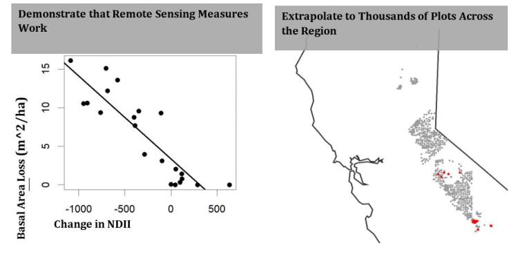
1) A plot showing a strong relationship between change in remotely sensed Normalized Difference Infrared Index (NDII) and basal area loss, an example of demonstrating how remote sensing measures may be used as a metric of mortality. 2) A map showing how existing plots (red) may be extrapolated across the region.