
Accurate maps of seasonal habitat for greater sage-grouse (Centrocercus urophasianus) are of paramount importance to conservation efforts in sagebrush ecosystems across the Great Basin, particularly for habitat assessments and mitigation efforts. However, the ability to model sage-grouse habitat at the fine spatial scales necessary for microhabitat assessment is constrained by the spatial and spectral resolution of most remotely sensed measurements of vegetation composition. As a continuation of previous shrub mapping efforts, the Western Ecological Research Center is utilizing multispectral imagery from Uncrewed Aircraft Systems (UAS) collected by the Center for Transformative Environmental Monitoring Programs (CTEMPS) at the University of Nevada, Reno, and WorldView satellite imagery from Maxar, Inc. to generate fractional cover maps containing detailed vegetation components. These high-resolution fractional cover maps will identify sagebrush, non-sagebrush shrub, forbs, and grasses. Estimates of vegetation components in training plots derived from ultra-high-resolution (less than 3-centimeter) UAS imagery and object-based image analysis are applied to high-resolution (2-meter) WorldView scenes using regression tree (RT) models. The approach yields fractional estimates of vegetation cover at a resolution that more closely correlates with actual microhabitat conditions compared to other widely available fractional products better suited for macrohabitat applications. An advantage of the UAS-RT approach is that large volumes of training data can be collected rapidly from UAS compared to traditional ground-based vegetation surveys, which could ultimately yield previously lacking estimates of microhabitat availability across macrohabitat or landscape level extents.
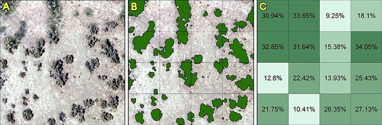
(A) Example of Artemisia tridentata in ultra-high-resolution Uncrewed Aircraft Systems (UAS) imagery. (B) Object-Based Image Analysis (OBIA) classification of sagebrush features. (C) Calculated percentage of sagebrush cover per 2-meter WorldView pixel.