
Validation is a critical component of product development that helps evaluate a product’s utility and limitations for users. In the development of global products, reference data must represent the wide variety of planetary conditions across space and time. While some global variables (temperature and surface radiation) can be validated from ground sensor networks, other variables, such as land cover or burned area, are far more difficult to validate, as they require generating global reference data that are based on higher resolution sensors than those used to obtain the global product. Further, because burned area is a temporary land cover condition, additional effort is required to find reference source imagery in which burned areas are visible.
Over the past two decades, several global burned area products have been produced and released to the public. However, the accuracy assessment of such products largely depends on the availability of reliable reference data that have not existed on a global scale or whose production requires a high-level dedication of project resources. In an international effort, led by Universidad de Alcalá in Spain, multiple international research teams, including the USGS, have come together to compile and standardize burned area reference datasets based on Landsat and Sentinel-2.
This effort provides the first publicly available global Burned Area Reference Database (BARD), created by compiling existing reference burned area datasets from different international projects. BARD contains 2,661 reference burned area files derived from Landsat and Sentinel-2 imagery. To ensure database consistency, all files were transformed to a common format and were properly documented by following metadata standards. This effort will improve the resource and time efficiency of future efforts to generate new and improved burned area products across the globe.
https://edatos.consorciomadrono.es/dataset.xhtml?persistentId=doi:10.21950/BBQQU7.
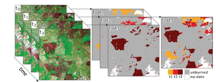
Schematic process of reference data generation. Consecutive pairs of images were selected from multitemporal Landsat image series of the same location (left) to derive the corresponding classified reference data files (middle), which were then merged to generate the reference data (right). Colors (middle, right) represent the dates in which the burned area patches were observed.