
The western U.S., including California, has experienced extreme weather events that have resulted in catastrophic and deadly fires. These destructive fires have resulted in loss of life and property, and burned through iconic landscapes within the National Park Service (NPS). This ongoing project measures the impact and landscape response of these fires on three national parks in California. In the 2018 Carr Fire, 97% of the Whiskeytown National Recreation Area burned across mixed coniferous communities. In 2020, 70% of Lava Beds National Monument burned across its sagebrush and native grassland ecosystem. And also in 2020, the Dome Fire burned over 43,000 acres across the Mojave National Preserve, damaging one of the most extensive and robust Joshua tree stands. USGS is providing technical support and using multi-scale remote sensing tools to assess 1) fire impacts to vegetation and cultural resources, and 2) vegetation landscape recovery or change. USGS staff are conducting field surveys of topography (using Real Time Kinematic GPS), fire effects on vegetation, and vegetation recovery following fire. Results of the field surveys are being paired with data collected using Uncrewed Aircraft Systems (UAS) and satellite imagery to create spatial products at different scales. This information is directly being used by NPS staff to inform management intervention and plan for recovery. WorldView-2 imagery was recently acquired for Lava Beds National Monument and Mojave National Preserve to delineate the fire extent across these remote regions. UAS acquisition occurred in Whiskeytown for the third sampling year, which is being paired with Landsat imagery to estimate forest change and recovery. Field surveys were conducted for ground validation for all three locations. With the continued threats of wildfire to DOI lands, a multi-scale approach can help inform ecosystem change, landscape conversion, and management intervention to prevent invasive species expansion.
https://www.usgs.gov/centers/werc/science/using-drone-imagery-assess-impacts-2018-carr-fire
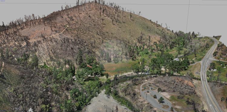
3D dense point cloud created from Uncrewed Aircraft System (UAS) surveys with a Ricoh GR II sensor and processed in Structure from Motion software. The dense point cloud is the base for derived products including orthoimagery and digital elevation models.