
In Prince William Sound in southern Alaska, climate change–driven glacial retreat is exposing steep, unstable slopes that could generate tsunamis if they failed rapidly and entered the fjords. One such area is the Barry Arm fjord, where the rapid retreat and thinning of the Barry Glacier is associated with several slope instabilities that threaten nearby communities, infrastructure, and marine interests. The largest of these landslides, measuring over 2 km in width, moved 120 m between 2010 and 2017 as the Barry Glacier retreated from the base of the slope (see https://doi.org/10.1029/2020GL089800). This landslide initiated a State and Federal multi-agency response in 2020, which included ground-based, aerial, and satellite monitoring efforts, community stakeholder involvement, and public outreach. In May of 2020, the USGS began monitoring the landslide movement using RADARSAT-2 synthetic aperture radar (SAR) satellite data. Maps of monthly landslide movement (interferograms) were created using interferometric SAR (InSAR) processing, which measures changes in the ground surface using the difference in the phase of the returning waves in the line of sight of the satellite radar sensor. Between late May and September, the landslide experienced little to no downslope movement. In October, InSAR monitoring captured landslide-wide downslope movement. Using several SAR scenes from both the RADARSAT-2 and Sentinel-1 satellites, USGS scientists determined that the center of the landslide moved about 30 cm. Subsequent modeling of landslide failure and tsunami scenarios has shown that a tsunami would impact much of the Prince William Sound, with wave heights of over 200 m in the northern part of Barry Arm fjord and peak heights of over 2 m offshore the town of Whittier (see https://doi.org/10.3133/ofr20211071). Monitoring active landslides with SAR data such as those in the Prince William Sound can improve emergency management efforts, landslide failure forecasts, and slope stability and tsunami modeling.
https://doi.org/10.5066/P9Z04LNK
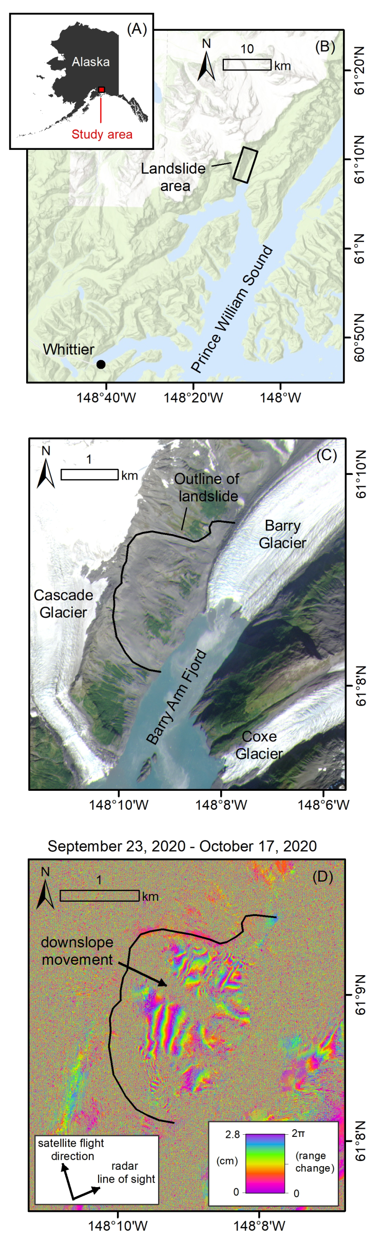
Location and InSAR displacement mapping results. (A) Prince William Sound located in southern Alaska. (B) The landslide area is located in the Barry Arm fjord, about 50 km northeast of the nearest city Whittier, with a year-round population of about 200 residents, which balloons during summer months when it becomes a hub of boating, fishing, and tourism. (C) The largest landslide in the Barry Arm Fjord measures over 2 km wide and moved ~120 m downslope between 2010 and 2017 as Barry Glacier thinned and retreated from the base of the slope. (D) An interferogram produced from the RADARSAT-2 satellite data shows downslope movement of the landslide. Each fringe (full color cycle, i.e., purple-purple) indicates 2.8 cm of movement. Speckle indicates areas where satellite measurements could not be made, such as over ice, water, vegetation, and very steep terrain.