
This project uses aerial imagery collected with Uncrewed Aircraft Systems (UAS, or “drones”) to assess and monitor vegetation at contaminated wetlands and neighboring lands being remediated and restored under the Great Lakes Restoration Initiative (GLRI). The project is a collaborative effort between the U.S. Environmental Protection Agency, USGS, and a private corporation hired to collect imagery. Researchers at the USGS Columbia Environmental Research Center are using UAS imagery and derived elevation products to map invasive plant species and vegetation communities at multiple sites of interest. These products provide baseline data on site vegetation profiles prior to remediation and restoration activities. Following remediation and habitat restoration, additional UAS imagery will be used to monitor and map the same species and communities to assess restoration progress. Data will also be used to support invasive species early detection/rapid response and long-term eradication and control programs to ensure that invasive species do not thwart restoration efforts and hinder ecosystem recovery.
Vegetation is just one element being monitored under the GLRI program to assess restoration progress and to determine if restoration goals are being met. When possible, opportunistic UAS imagery collection will be used to develop high-resolution elevation models to describe terrestrial topography and as a substitute for, or complement to, bathymetric (water depth) models from data collected using traditional methods. High-resolution elevation models will improve the ability to monitor fluctuations in water levels at GLRI sites and changes in topography and bathymetry following restoration implementation. Furthermore, these models will allow better comprehension of the relative role that water depth (in aquatic systems) and depth to ground water (in terrestrial systems) play in determining vegetation distribution in restored areas. Projects associated with the GLRI complement ongoing work on assessment, remediation, and restoration for the Department of the Interior Natural Resource Damage Assessment and Restoration Program.
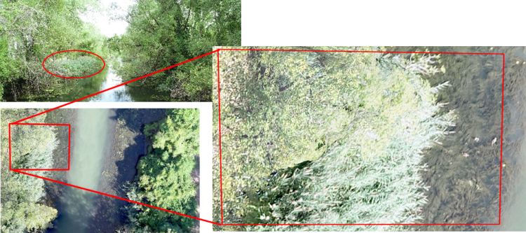
Photographs of Otter Creek, Ohio, showing patches of common reed (Phragmites australis) as visible from a boat at water level (red circle, upper left) and as identified from high-resolution (less than 2-centimeter ground distance resolution) aerial imagery collected using UAS at two scales (red boxes, lower left and right). Photo credit: U.S. Environmental Protection Agency.