
Microbial biofilm communities, which are comprised of bacteria, diatoms, protozoa, and fungi, inhabit the surface of intertidal mudflats. They play a major role in intertidal food webs and comprise a large proportion of shorebirds’ diets, so understanding biofilm distribution, quantity, and nutritional value is important for shorebird conservation and management. A key uncertainty in the South Bay Salt Pond Restoration Project, which is the largest tidal wetland restoration project on the West Coast, is whether sediment from adjacent mudflats will lead to erosion and potential impacts to biofilm. This study’s goal is to address that uncertainty by identifying seasonal and spatial variations in biofilm distribution, quantity, quality, and composition through development and scaling of hyperspectral algorithms.
Since ecological processes on intertidal mudflats influence biofilm at very small (mm to cm) to large (tens of km) spatial scales, the science plan takes a multi-scalar approach to model biofilm parameters. Team members use field- and ground-based imaging spectroscopy, Uncrewed Aircraft Systems (UAS), and airborne imaging spectroscopy to capture measurements of chlorophyll-a (an indicator of biomass), lipids, total organic carbon, glucose, and community composition. In a partnership with the USGS Western Ecological Research Center (WERC), the USGS Western Geographic Science Center, the USGS National UAS Project Office, the USGS Spectroscopy Lab, and California State University Monterey Bay, in spring 2021 multi-scale hyperspectral data were collected on biofilms with multiple sensors: a field spectrometer, the HySpex VNIR/SWIR imaging spectrometer (5-millimeter resolution), the Resonon Pika L VNIR UAS camera (4-centimeter resolution), and the AVIRIS-NG airborne imaging spectrometer (4-meter resolution).
High-resolution spectra for biofilm end-members will be used to scale algorithms of composition, quality, and quantity to the greater South San Francisco Bay region where the restoration project is located. This work is part of a larger WERC-led project on “Quantifying Drivers and Stressors of Intertidal Biofilm Resources at the Largest Tidal Wetland Restoration on the U.S. West Coast.” Results will support measurement and visualization of habitat quality for shorebirds as well as understanding of the influence of wetland restoration activities on biofilm resources.
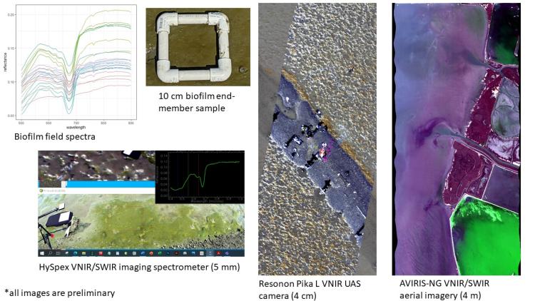
Multiscale spectroscopy of intertidal biofilms with a field spectrometer, HySpex ground-based imaging spectrometer, Resonon Pika L UAS hyperspectral camera, and AVIRIS-NG airborne imagery are being used to scale hyperspectral algorithms of biofilm quantity, quality, and composition to the South San Francisco Bay region.