
The intersection of land use, water use, water availability, and climate change demands attention as resource constraints increasingly threaten human health and welfare. Long-term analyses of historical-to-current feedbacks among land use, water resources, and climate may support managers’ ability to anticipate potential feedbacks that could threaten human activities in the future. Remote sensing provides the consistent, synoptic data coverage to support analyses of land use and hydrologic change under a changing climate, while anticipatory, scenario-based models can leverage remote sensing-based analyses to explore potential futures and facilitate planning and mitigation activities.
The Earth Resources Observation and Science (EROS) Center completed long-term modeling in the Delaware River Basin (DRB) using remotely sensed observations of landscape change to inform a spatially explicit model that temporally extended the land cover record both backward and forward in time. In FY2021 work has focused on linking monitoring and modeling of water use and water availability with the EROS FOREcasting SCEnarios of Land-use Change (FORE-SCE) model. The goal is to move toward true parcel-based water accounting, where water use and water availability are tracked at the field level, informing scenarios of future agricultural and landscape change under a changing climate.
The initial focus is on assessing feedbacks between water use and land use, using a remote sensing-based approach for determining evapotranspiration. Two different approaches were applied in the DRB: the Vegetation ET (VegET) model and the operational Simplified Surface Energy Balance (SSEBop). VegET is a water-balance approach that uses remote sensing to categorize land-surface phenology and precipitation inputs, while SSEBop is an energy-balance approach that uses land-surface temperature from remote sensing. Each characterized ET and water use for the DRB, with an intersection of ET and land use quantifying water use trends by land use type over time. Investigations into models of water availability were also started, with the Precipitation Runoff Modeling System (PRMS), Modular Hydrologic Model (MODFLOW), and MODSIM identified as key models for potential model integration with FORE-SCE, with model choice dependent upon scale of application. FY21 work focused on exploring the conceptual and practical issues of water availability model coupling with FORE-SCE, with formal coupling initiated in FY22. Continuing work strives to improve the representation of feedbacks between land use, water use, water availability, and climate.
https://www.usgs.gov/land-resources/eros/lulc; VegET (https://www.mdpi.com/1999-4893/1/2/52 ); SEEBop (https://doi.org/10.13031/aea.12614)
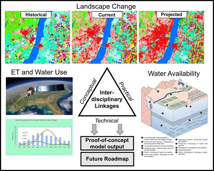
Remote sensing forms the core of a modeling effort in the Delaware River Basin to assess feedbacks among land use, water use, and water availability as USGS researchers move toward parcel-based water accounting under a changing climate.