
The USGS Water Availability and Use Science Program (WAUSP) systematically provides information that allows water resource managers to assess availability of the Nation’s water. The USGS focuses on development of advanced techniques for evapotranspiration (ET) estimates to better measure various agricultural-based water budget components for informing decision makers. Specifically, National Water Census (NWC) goals support systematic geospatial analysis and evaluation of joint performance of the operational Simplified Surface Energy Balance (SSEBop) and Vegetation ET (VegET) models for quantifying net irrigation water use, also referred to as NetET.
Scientists at the USGS Earth Resources Observation and Science (EROS) Center are leveraging MODIS (250-meter) and Landsat (30-meter) remote sensing data to generate model analysis products such as VegET (rainfall-based ET), SSEBop ET (total water use), and NetET (irrigation water use), along with rainfall and other ancillary datasets. Project cloud-processing components include both Amazon- and Google-based computing services for creating more accurate and timely raster data maps for the conterminous United States (CONUS) for 2015 annual ET, a target study evaluation year. Data summation and integration includes national-scale irrigation layer masks within hydrologic unit boundaries (HUC12) for evaluation of measurements at consistent and appropriate scales.
Results include accuracy assessment feedbacks of NetET information products for the improvement and implementation of current and future national water accounting methods applying satellite-driven techniques. This work supports and advances ongoing investigation of the relationships between optical and thermal datasets for ET modeling, including performance of the SSEBop ET and VegET models using best available physical and process parameters.
The EROS Center develops and shares these NetET products with USGS Water Science Centers and NWC partners around the Nation for evaluation and water use reporting needs. For successful development and integration of such new accounting methods for NWC components, multi-layered collaboration from technical components to project coordination is instrumental for ensuring data aggregation and assimilation with other Federal, State, regional, local, and Tribal resource managers.
https://www.usgs.gov/water-resources/water-availability-and-use-science-program
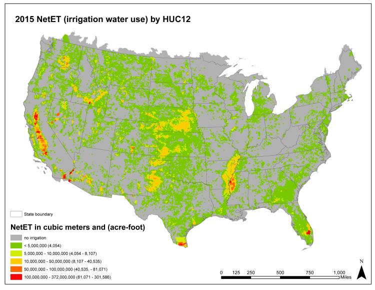
Annual irrigation water use for 2015 summarized by hydrologic unit code level 12 (HUC12).