

When the Earth shook Alaska 52 years ago—on Good Friday, March 27, 1964—tsunamis wiped out entire villages. Landslides swept Anchorage neighborhoods into Cook Inlet. A collision of tectonic plates comprising the planet’s outermost layer had caused a 9.2 magnitude earthquake, the largest in U.S. history, and killed 131 people.
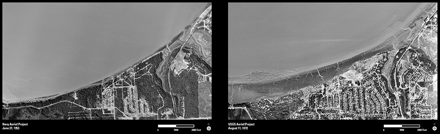
Aerial photographs archived at the USGS Earth Resources Observation and Science (EROS) Center capture the quake’s dramatic impact on Anchorage’s coastal boundaries. In the 1953 image, the Turnagain neighborhood west of the city’s downtown area is only beginning to emerge from the trees along the inlet. Eight years after the disaster, in 1972, the wooded shoreline has vanished, the bluffs now submerged in a sediment band created by the cataclysmic actions of the temblor. Yet extensive new development shows that Anchorage continued to expand in this area.
These are just two of the 6.5 million aerial photographs that span the last 80 years and are available on the USGS EarthExplorer Web site. Along with millions of other data files in the EROS archive that have been acquired from satellites, airborne radar, and the U.S. space program, these aerial photographs tell an important and compelling story about land cover that is ever changing, both in the United States and around the globe.