

Grasslands made lush by summer rains in 2015 have turned into a tinderbox along the Kansas-Oklahoma border after a dry winter and gusty spring winds transformed the withering vegetation into fire fuel.
The latest in a season of wildfires is the 350 Complex Fire near Freedom, OK, just south of the Kansas border and south of the Cimarron River. On April 5, 2016, four fires sparked by downed power lines merged into one and burned almost 57,500 acres in three days. In late March, the Anderson Creek Fire—the largest blaze ever in Kansas—started in Oklahoma and spread into Kansas, burning almost 400,000 acres.
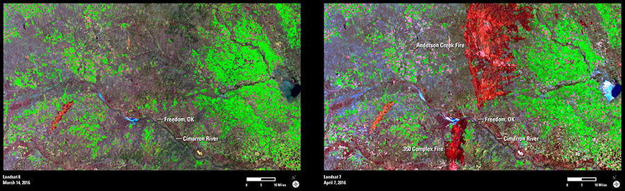
Using shortwave infrared, near infrared, and visible bands, these Landsat images provide a before and after look at the 350 Complex and Anderson Creek fires. In the March 14 image acquired by Landsat 8, a minor scar from an earlier fire appears orange in the lower left corner. The fan-shaped blue and black object at the center right edge of the image is the Great Salt Plains Lake and Salt Plains National Wildlife Refuge in Oklahoma.
On April 7, Landsat 7 captured the large, brilliant red burn scars caused by the fires.
As of April 8, the National Interagency Fire Center in Boise, ID, reported that 817,480 acres had burned year-to-date across the country, the largest tally in that time frame since 2006.