

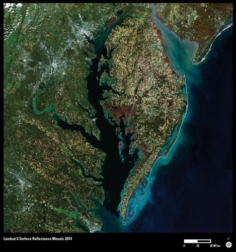
Chesapeake Bay is the Nation’s largest estuary and its restoration and protection is a priority. The USGS provides scientific information to help manage this vital ecosystem. As part of that role, staff at the USGS Earth Resources Observation and Science (EROS) Center created this true color composite image. The image was created using Provisional Surface Reflectance data from five Landsat 8 scenes, acquired in October and November 2014.
Provisional Surface Reflectance processing includes atmospheric correction to reduce haze, aerosol, water vapor, and ozone effects from Landsat Level 1 processed data. The enhanced processing makes this seamless mosaic possible and provides a sharper view of the Earth’s surface, as if there were no atmosphere interrupting the view between the satellite and ground.
Chesapeake Bay is the dark shape stretching up through the center of the image. Sediment in the water appears either light blue or green. Baltimore, Maryland, and Washington, DC, are the two bright areas near the upper left. The peninsula across the Chesapeake from these cities is a patchwork of farm, forest, and protected areas.
All Landsat Surface Reflectance products are available through the EROS Science Processing Architecture (ESPA) On Demand Interface (http://espa.cr.usgs.gov) and EarthExplorer (http://earthexplorer.usgs.gov).
For more information, see http://landsat.usgs.gov/CDR_ECV.php.