

This image from the European Space Agency’s Sentinel-2A satellite offers a breathtaking view of Crater Lake National Park in southern Oregon. It offers something equally important to park managers, scientists, and anyone else interested in land cover change—a view that is highly similar and complementary to Landsat acquisitions.
In this 100th anniversary year of the National Park Service, land managers and scientists tasked with overseeing parks and other government-owned lands typically rely on frequent remote imaging to monitor changes to forests, vegetation, hydrology, and more. Frequent imagery means observers can detect change quicker, and address or manage the effects of change in a more timely fashion.
With its potential repeat coverage of every 10 days, Sentinel-2A should eventually provide additional revisit opportunities to the 8-day coverage from Landsats 7 and 8 combined. Sentinel-2A has spectral bands similar to Landsat 8, with a higher spatial resolution in several bands. So at Crater Lake, for example, a hydrologist seeking information on the amount of snow cover in the high country around the lake, and the subsequent snowmelt, should benefit in the future from more potential images.
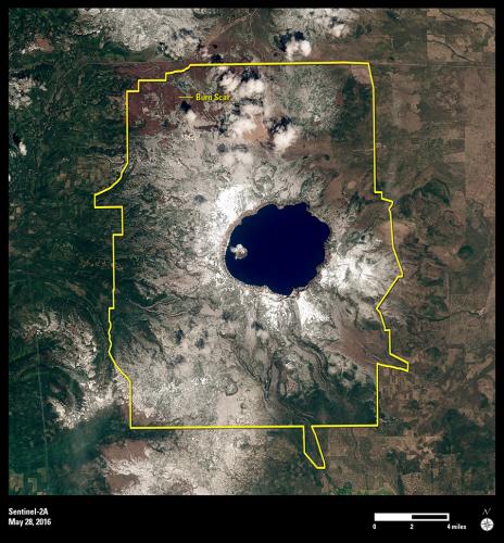
Beyond scientific use, Sentinel-2A, like the Landsat satellites, offers a stunning view of the national park, which was established in 1902—14 years before the National Park Service came into being. Crater Lake formed 7,700 years ago when the volcano Mount Mazama erupted and collapsed into itself, creating the deepest lake in the United States. A burn scar visible just north of the lake in this image was caused by a wildfire in August 2015.
Sentinel-2A imagery is free and can be downloaded through EarthExplorer or GloVis, online search and order tools available through USGS.