

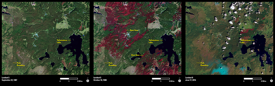
In the summer of 1988, a wildfire ravaged the world’s first national park, consuming 1.2 million acres in and around the Greater Yellowstone Park ecosystem. Landsat imagery became an important record of the burn severity and recovery.
As we celebrate the 100th anniversary of the National Park Service, which was established to better manage Yellowstone and other national parks within the Department of Interior, Landsat continues to prove the outstanding value of its land-monitoring mission. The June 2016 image, captured by Landsat 8, portrays the widespread recovery of tree cover and other vegetation within the 28-year-old burn scar.
The national park’s western border is easily evident in images acquired shortly before and after the fire, on Sept. 22, 1987, and again on Oct. 10, 1988. A prohibition on logging in the national park is revealed in a dividing line of land use that shows dark green forests to the right of the park boundary, and the pink and light green hues of forest clearcuts to the left.
Yellowstone’s healing since the fire is obvious in the time-series views as well. Landsat 5’s shortwave infrared, near-infrared, and red bands combine in the October 1988 image to reveal vibrant red burn scars above and below Yellowstone Lake. In 2016, the scars have faded beneath the lush, green forest canopies and resurgent grasslands.