

On October 29, 2012, Hurricane Sandy barreled across the shorelines of New Jersey, New York, and Connecticut, impacting lives across two dozen states that fell within its destructive path.
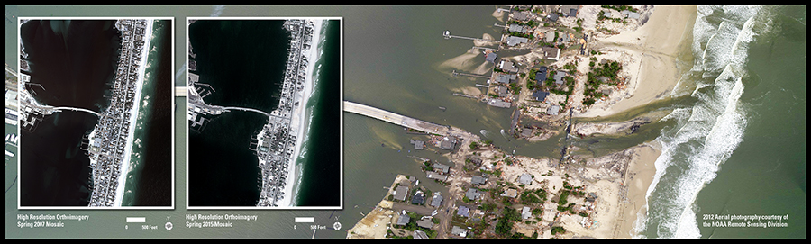
High Resolution Orthoimagery archived at the USGS EROS Center and inset into the larger image show the New Jersey coastal town of Mantoloking five years before Sandy made landfall, as well as the slow recovery three years after the storm. Entire blocks of houses visible in the 2007 image were damaged or completely washed away by the storm surge and wind, replaced by empty patches of sand in the 2015 image.
The larger background image acquired by the Remote Sensing Division of the National Oceanic and Atmospheric Administration in the days after the storm in 2012 shows the immediate devastation, including a breach cut across the island and connecting the Atlantic Ocean to Barnegat Bay.
The Mantoloking Bridge was covered in water, sand, and debris from houses after the storm. Built for roughly $25 million and opened in 2005, it was closed after Sandy went through because county officials considered it unstable, and didn’t reopen until the first week of January 2013.