

On June 28, 2016, a 4,000-foot-high mountainside in Glacier Bay National Park and Preserve collapsed, sending rocky debris equivalent to 60 million mid-size SUVs tumbling onto nearby Lamplugh Glacier.
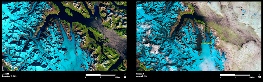
Almost 6 weeks later, on August 7, the Operational Land Imager sensor aboard Landsat 8 captured the black stain of the landslide in the image on the right. No such discoloration is evident in the Landsat image to the left, acquired on September 13 of the previous year. Seismologists analyzed the seismic waves created by the event and estimated that the slide accelerated for almost a minute as it tumbled over a mile down the mountain and continued to slide along the glacier for another 6 miles.
As we celebrate the 100th anniversary year of the National Park Service, this timely event is a powerful reminder of how unstable mountains are in the southeast corner of Alaska. The region is geologically active, with mountains being pushed up as tectonic plates move, and is considered a global hotspot for such landslides.
Glacier Bay became a national monument on February 25, 1925, and was established as a national park and preserve on December 2, 1980. The park now covers 3.3 million acres. Landsat sensors will continue to monitor landslide activity in this remote region as they have for the past 44 years.