

Kīlauea, Hawaii, USA
Earth Resources Observation and Science (EROS) Center - Earthshots
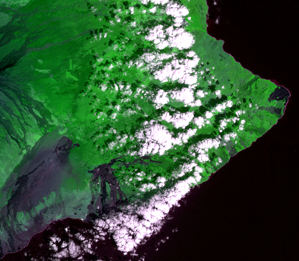
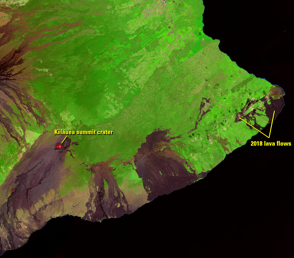
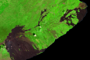
In 2018, Hawaii was in the news as fresh lava covered 13.7 square miles (35.5 km2) at the eastern end of the Big Island. Of course, lava flows in Hawaii are nothing new. Satellite imagery shows evidence of many lava flows from the past, appearing like dark curtains draped across the southern coast of the island.
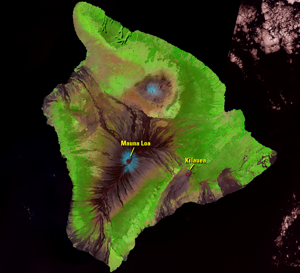
The lava flows on this part of the island are from Kīlauea, the youngest volcano on the Island of Hawai‘i. Almost all of Kīlauea’s surface is made up of rock that is less than 1,000 years old. It’s on the southeastern flank of Mauna Loa but has its own magma plumbing system, so it’s a separate volcano. This shield volcano is one of the world’s most active.
Imagery
Every picture has a story to tell
Correlated
Additional story information
Downloads
Andrews, R., 2019, Hawaii’s Kilauea Has Been Silent For Months, But It’s Not Dead: Forbes, accessed May 17, 2019, at https://www.forbes.com/sites/robinandrews/2019/02/01/hawaiis-kilauea-has-been-silent-for-months-but-dont-think-its-dead/#93bec1667004.
Cole, W., and Nakaso, D., 2018, 2014 lava flow spared Pahoa of devastation: Honolulu Star Advertiser, https://www.staradvertiser.com/2018/05/04/hawaii-news/2014-lava-flow-spared-pahoa-of-devastation/.
Leman, J., 2019, Five explosive things the 2018 eruption taught us about Kilauea: Science News, accessed May 17, 2019, at https://www.sciencenews.org/article/five-explosive-things-2018-eruption-taught-us-about-kilauea.
Neal, C.A., Brantley, S.R., Antolik, L., and others, 2019, The 2018 rift eruption and summit collapse of Kīlauea Volcano: Science, v. 363, no. 6425, p. 367–374, accessed May 17, 2019, at http://science.sciencemag.org/content/363/6425/367.
Poland, M.P., Takahashi, T.J., and Landowski, C.M., eds., 2014, Characteristics of Hawaiian volcanoes: U.S. Geological Survey Professional Paper 1801, 429 p., http://dx.doi.org/10.3133/pp1801.
Rubin, K., 2016, A Brief History of the Pu`u `O`o Eruption of Kilauea: Hawaii Center for Volcanology, accessed May 17, 2019, at https://www.soest.hawaii.edu/GG/HCV/puuoo_history.html.
Smithsonian Institution, 2019, Kilauea: Smithsonian Institution National Museum of Natural History Global Volcanism Program, accessed May 17, 2019, at http://volcano.si.edu/volcano.cfm?vn=332010.
USGS, 2017, Volcano Hazards Program: USGS Hawaiian Volcano Observatory, accessed May 17, 2019, at https://volcanoes.usgs.gov/observatories/hvo/hvo_gas.html.
USGS, 2018, Kīlauea: USGS Volcano Hazards Program, accessed May 17, 2019, at https://volcanoes.usgs.gov/volcanoes/kilauea/.
USGS, 2016, Kīlauea Volcano Erupts in Explosive and Effusive Cycles: USGS Volcano Hazards Program, accessed May 17, 2019, at https://volcanoes.usgs.gov/volcanoes/kilauea/geo_hist_summary.html.
USGS, 2019, The Pu‘u ‘Ō‘ō Eruption Lasted 35 Years: USGS Volcano Hazards Program, accessed May 17, 2019, at https://volcanoes.usgs.gov/volcanoes/kilauea/geo_hist_1983.html.
USGS, 2019, Volcano Watch: USGS Volcano Hazards Program, accessed May 17, 2019, at https://volcanoes.usgs.gov/observatories/hvo/hvo_volcano_watch.html?vwid=1397.
USGS, 2019, Current Maps: USGS Volcano Hazards Program, accessed May 17, 2019, at https://volcanoes.usgs.gov/volcanoes/kilauea/multimedia_maps.html.
USGS, 2018, Hazards Data Distribution System Releases Thousands of Aerial Images of Kilauea Impact: USGS, accessed May 17, 2019, at https://www.usgs.gov/center-news/hazards-data-distribution-system-releases-thousands-aerial-images-kilauea-impact?qt-news_science_products=1#qt-news_science_products.
USGS, 2018, Kīlauea Volcano Erupts: USGS, accessed May 17, 2019, at https://www.usgs.gov/news/k-lauea-volcano-erupts.
Other Stories
Related imagery and additional content
2018 Eruption
On April 30, 2018, rapid changes in the East Rift Zone were detected. ...
End of the Pu‘u ‘Ō‘ō Eruption
Meanwhile, at the summit of Kīlauea, the Halema‘uma‘u crater and surro...
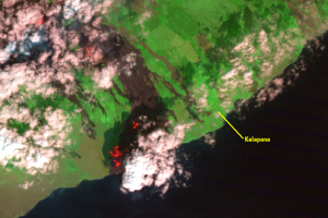
Kalapana
The Pu‘u ‘Ō‘ō eruption took a destructive turn in March 1990. Breakout...
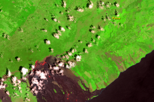
Pāhoa
On June 27, 2014, new fissures erupted just east of Pu‘u ‘Ō‘ō crater a...

Pu‘u ‘Ō‘ō
The 2018 eruption was part of an ongoing eruption sequence that starte...