

Lake Chad, West Africa
Earth Resources Observation and Science (EROS) Center - Earthshots
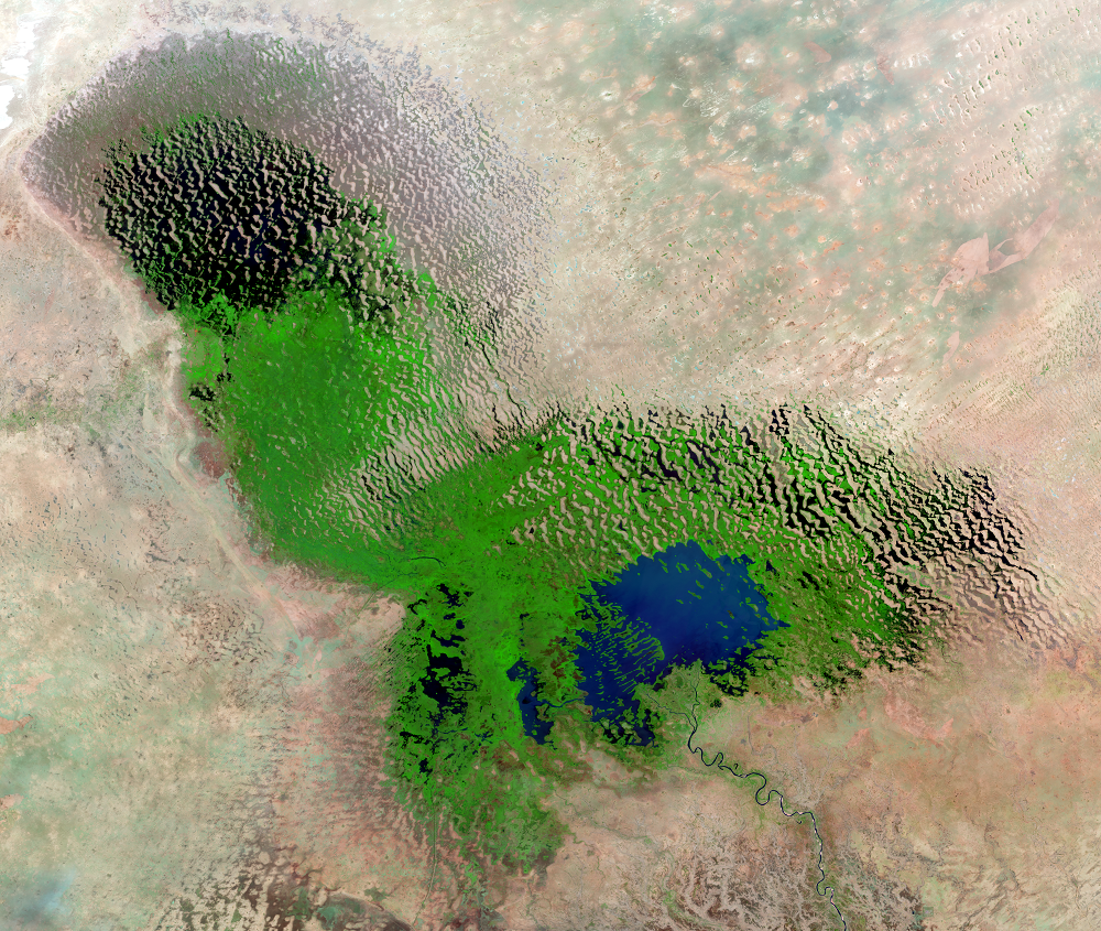
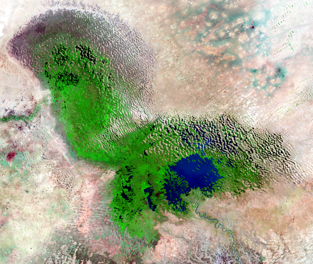
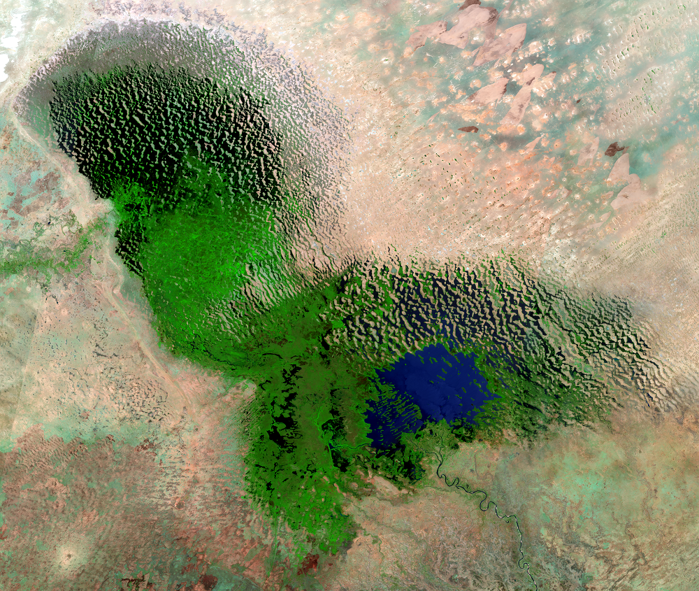
Lake Chad was once the sixth largest lake in the world, but prolonged drought and increased water use have shrunk the lake dramatically. It now spans less than a tenth of the area it covered in the 1960s. Back then, the lake covered about 25,000 square kilometers, an area the size of the U.S. state of Vermont. Now it’s smaller than Rhode Island.
The fluctuations in lake water levels have stabilized in recent years, but it is still a dynamic environment. Social conflicts and insecurity in the region make it difficult to monitor water levels with ground-based measurements. Satellite imaging has therefore been crucial to monitoring the changes to the lake, especially with the infrared bands on Landsat sensors, which make it easier to distinguish water and vegetation.
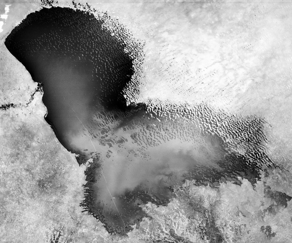
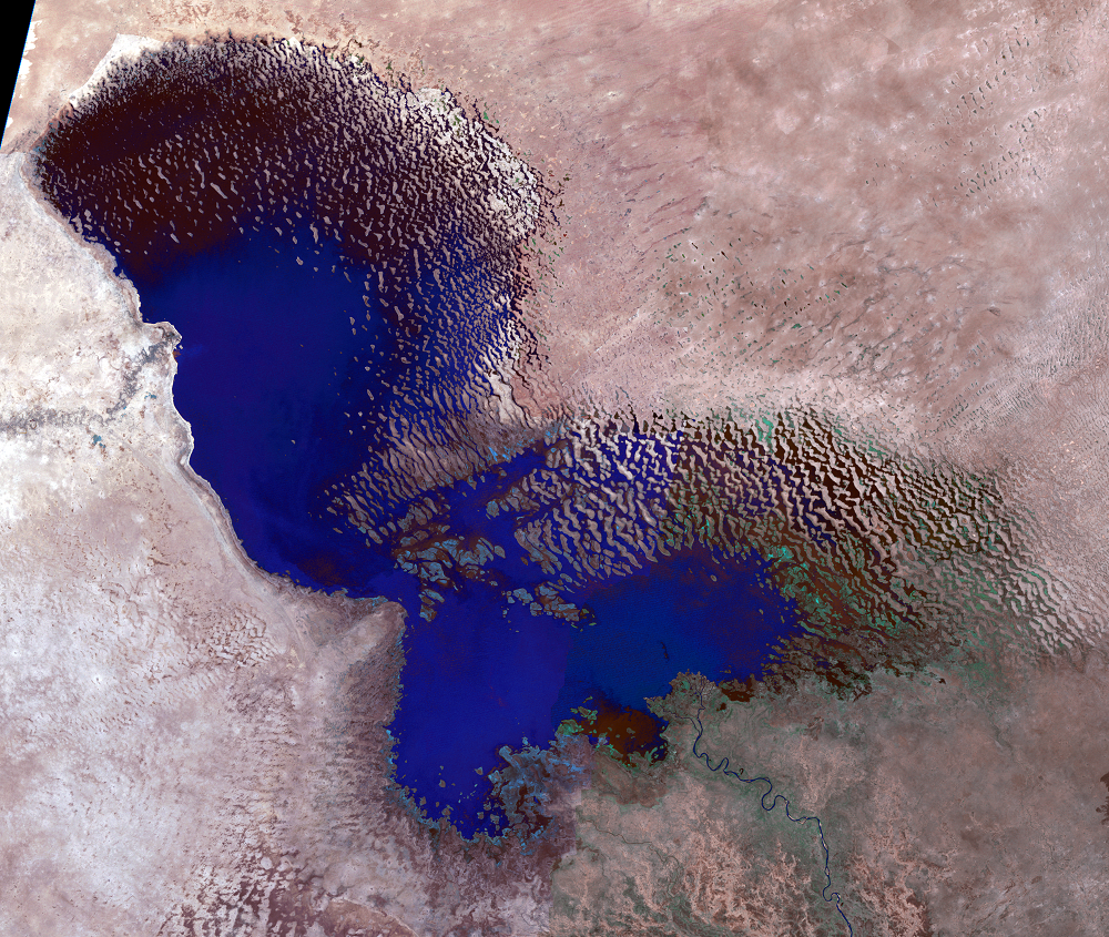
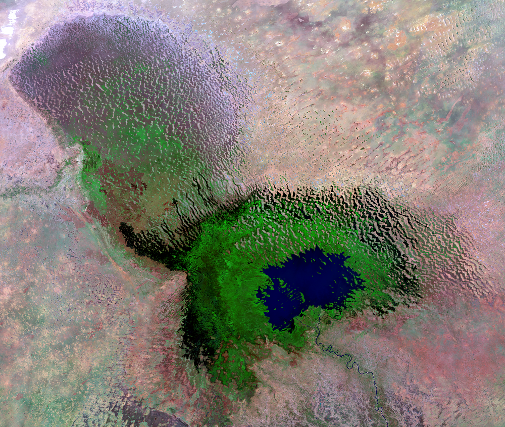
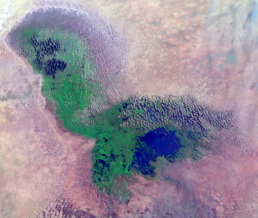
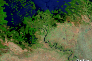
These Landsat images show the overall transition of Lake Chad from open water to wetland. The desert appears tan, wetlands are green, and open water is blue.
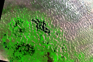
The black and white 1963 image is from the film-based Argon reconnaissance satellite program, declassified in the 1990s.
Imagery
Downloads
Asante, K.O., Artan, G.A., Pervez, S., and Rowland, J., 2008, A linear geospatial streamflow modeling system for data sparse environments: International Journal of River Basin Management, v. 6, no. 3, p. 233–241.
Bloemen, S., 2011, Lake Chad’s receding water level heightens risks of malnutrition and disease: UNICEF, available online at http://www.unicef.org/infobycountry/chad_57642.html. (Accessed June 7, 2012.)
Buma, W.G., Lee, S.-I., and Seo, J.Y., 2018, Recent Surface Water Extent of Lake Chad from Multispectral Sensors and GRACE: Sensors, v. 18, no. 7, p. 2082, https://www.ncbi.nlm.nih.gov/pmc/articles/PMC6069056/.
Coe, M.T., and Birkett, C.M., 2004, Calculation of river discharge and prediction of lake height from satellite radar altimetry: Example for the Lake Chad basin: Water Resources Research, v. 40, W10205, doi:10.1029/2003WR002543.
Deutsche Gesellschaft für Internationale Zusammenarbeit (GIZ), 2016, Report on the State of the Lake Chad Basin Ecosystem: Bonn, Germany, 233p., accessed November 20, 2018, at http://www.cblt.org/sites/default/files/download_documents/report_on_the_state_of_the_lake_chad_basin_ecosystem.pdf.
Gao, H., Bohn, T.J., Podest, E., McDonald, K.C., and Lettenmaier, D.P., 2011, On the causes of the shrinking of Lake Chad: Environmental Research Letters, v. 6, 034021, doi:10.1088/1748-9326/6/3/034021. (Also available online at http://iopscience.iop.org/1748-9326/6/3/034021.)
Grove, A.T., 1978, Geographical introduction to the Sahel: The Geographical Journal, v. 144, no. 3, p. 407–415.
Hansen, K., 2017, The Rise and Fall of Africa’s Great Lake: NASA Earth Observatory, accessed April 20, 2018, at https://earthobservatory.nasa.gov/Features/LakeChad/.
Hutchinson, C.F., Warshall, P., Arnould, E.J., and Kindler, J., 1992, Development in arid lands—lessons from Lake Chad: Environment, v. 34, no. 6, p. 16–43.
Ibrahim, T., Nichol, J. E., and Birkett, C. M., 2007, Relationship between altimeter data and areal extent of water in the Lake Chad Basin, in Asian Conference on Remote Sensing, Kuala Lumpur, Malaysia, Nov. 12–16, 2007, Proceedings: Asian Association on Remote Sensing, available online at https://www.researchgate.net/publication/237646529_Relationship_between_altimeter_data_and_areal_extent_of_water_in_the_Lake_Chad_Basin. (Accessed September 17, 2012.)
Jackel, D., 1984, Rainfall patterns and lake level fluctuations at Lake Chad, in Morner, N.A., and Karlen, W. eds., Climatic Changes on a Yearly to Millennial Basis: Dordrecht, Holland, D. Reidel Publishing, p. 191–200
Kolawole, A., 1987, Environmental change and the South Chad Irrigation Project (Nigeria): Journal of Arid Environments, v. 13, p. 169–176.
Lopez, T., Antoine, R., Kerr, Y., Darrozes, J., Rabinowicz, M., Ramillien, G., Cazenave, A., and Genthon, P, 2016, Subsurface Hydrology of the Lake Chad Basin from Convection Modelling and Observations: Surveys in Geophysics, v. 37, no. 2, p. 471–502, https://doi.org/10.1007/s10712-016-9363-5.
Olivry, J-C., Chouret, A., Vuillaume, G., Lemoalle, J., and Bricquet, J-P., 1996, Hydrologie du lac Tchad: Paris, ORSTOM, 266 p.
Policelli, F., Hubbard, H., Jung, H.C., Zaitchik, B., and Ichoku, C., 2018, Lake Chad Total Surface Water Area as Derived from Land Surface Temperature and Radar Remote Sensing Data: Remote Sensing, v. 10, no. 2, https://doi.org/10.3390/rs10020252.
Salkida, A., 2012, Africa’s vanishing Lake Chad: Africa Renewal, v. 26, no. 1, p. 24–25, available online at http://www.un.org/en/africarenewal/vol26no1/lake-chad.html. (Accessed June 7, 2012.)
Schneider, S.R., McGinnis, D.F., Jr., and Stephens, G., 1985, Monitoring Africa’s Lake Chad basin with Landsat and NOAA satellite data: International Journal of Remote Sensing, v. 6, no. 1, p. 59–73.
ScienceDaily, 2001, Africa’s Lake Chad shrinks by 20 times due to irrigation demands, climate change: ScienceDaily, available online at http://www.sciencedaily.com/releases/2001/02/010228080245.htm. (Accessed June 7, 2012.)
ScienceDaily, 2012, Lake Chad—Inhabitants adapt to lower water levels: ScienceDaily, available online at http://www.sciencedaily.com/releases/2012/02/120228140537.htm. (Accessed June 7, 2012.)
UNEP, 2004, Lake Chad Basin—GIWA Regional assessment 43: Fortnam, M.P. and Oguntola, J.A. (eds), Global International Waters Assessment, University of Kalmar, Kalmar, Sweden, 154 p. (Also available online at http://wedocs.unep.org/handle/20.500.11822/8398.)
UNEP, 2005, Water— Lake Chad, Africa, in One planet, many people—atlas of our changing environment: Nairobi, Kenya, United Nations Environment Programme (UNEP), p. 140–141.
UNEP, 2010, Transboundary Water Resources—Lake Chad Basin, in Africa Water Atlas: Nairobi, Kenya, United Nations Environment Programme (UNEP), p. 46–53.
U.S. Agency for International Development, Famine Early Warning System, 1997, Lake Chad—untapped potential: FEWS Special Report 97-4.
Thanks to Jean-Claude Olivry of ORSTOM for his assistance.
Related Content
Seasonal Variations
While the overall trend in this time series is a shrinking lake, the n...
Water Level Fluctuations
Lake Chad’s lakebed is flat and shallow, so small changes in water lev...