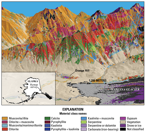
Alaska is a major producer of base and precious metals and has a high potential for additional undiscovered mineral resources. However, discovery is hindered by Alaska’s vast size, remoteness, and rugged terrain. Hyperspectral remote sensing is one method that can be used to rapidly acquire data about the distributions of surficial materials, including different types of bedrock and ground cover. The USGS is conducting the Alaska Hyperspectral Project to assess the applicability of this technology in Alaska (http://minerals.usgs.gov/science/hyperspectral-AK-mineral-deposits/). The primary study area is a remote part of the eastern Alaska Range where porphyry deposits are exposed.
This project applies an integrated approach that combines spectroscopic measurements with field- and laboratory-based geologic investigations. Hyperspectral data (also known as imaging spectrometer data) have been collected at the following scales: (1) regional, (2) outcrop, and (3) hand specimen. The regional airborne survey, conducted over 2 days, used the HyMap(TM) sensor and captured the spectral characterization of surface materials across an extensive area (1,900 km2) at 6-m resolution. A ground-based outcrop-scale survey done with the hand-held HySpex(TM) sensor provides higher spatial resolution mineral mapping over a kilometer-scale hillside at 30-cm resolution. The most detailed data were collected at 500-μm spatial scale on individual rock samples in the laboratory using Corescan’s Hyperspectral Core Imager Mark III(TM) imaging spectrometer. Analyses of these measurements reveal complex spatial relations of minerals. The hand specimen and outcrop results are used to improve interpretations of the regional hyperspectral dataset.
The hyperspectral surveys provide key pieces of information. Mineral classification maps show the predominant minerals for each spectrum. The USGS has taken steps to extract even more information from the spectral data by developing methods to determine qualitative abundances of the predominant minerals across the survey area. Subtle changes in the shapes of spectral features are also being examined to map differences in the chemical composition of select minerals. Variations in rock type are generally reflected by relative abundances of predominant minerals and observed compositional differences of some minerals . In this study area, muscovite spectral features are empirically observed to change with proximity to porphyry copper deposits.
http://minerals.usgs.gov/science/hyperspectral-AK-mineral-deposits/

Regional mineral classification map overlaying a digital elevation model of the Orange Hill area, Wrangell–St. Elias National Park and Preserve, Alaska. Colors represent the spectrally dominant minerals. Data collected at 6-m spatial resolution.

