
Scientists from eight USGS Science Centers completed a multidisciplinary data collection effort during the week of October 21–25, 2019, using new technologies to map and validate bathymetry over a large stretch of the non-tidal Potomac River. The work was initiated as an effort to validate commercially acquired bathymetric light detection and ranging (lidar) data collected over two areas of interest and jointly funded through a partnership between the USGS and the Interstate Commission on the Potomac River Basin (ICPRB). Work continued in 2020 to compare delivered airborne lidar data to bathymetric data collected in the field using more traditional means such as boat-based sonar and wading RTK-GPS surveys. USGS researchers participating in data collection and analysis include staff from the USGS Leetown Science Center, Earth Resources Observation and Science Center, National Geospatial Program, Woods Hole Science Center, Maryland-Delaware-DC Water Science Center, Virginia-West Virginia Water Science Center, Florence Bascom Geoscience Center, and the Water Mission Area Hydrologic Remote Sensing Branch. Additional assistance is being provided by the staff of the ICPRB. In addition to accurately measuring river bottom elevations with GPS and sonar, remote sensing imagery—optical, multispectral, and thermal—was collected in the field using unmanned aircraft systems (UAS) to test new technologies. The bathymetric lidar data, once validated, will be used for hydrodynamic and water supply risk modeling, aquatic habitat assessments, and inland bathymetry mapping and inclusion in the USGS 3D Elevation Program.
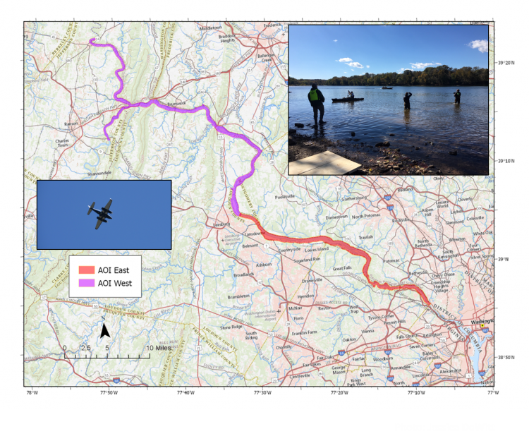
Areas of interest (AOIs) for collection of airborne bathymetric light detection and ranging (lidar) over portions of the non-tidal Potomac River from Little Falls Dam to Shepherdstown, West Virginia, including a portion of the Shenandoah River. Photo credits: Matt Cashman and Jack Eggleston, USGS.