

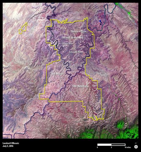
In September 1964, Interior Secretary Stewart Udall successfully shepherded some of the most remote and rugged terrain within the continental United States into the jurisdiction of the National Park Service (NPS) with the creation of Canyonlands National Park in southeastern Utah.
In this 100th anniversary year of the NPS, the Operational Land Imager (OLI) on Landsat 8 has acquired a stunning, false-color image that enhances the park’s irregular topography. No paved roads exist to join together the park’s three main districts—Island in the Sky, the Needles, and the Maze. The Horseshoe Canyon Unit is the detached part of the park in the upper left corner of the image.
In the high desert of the Colorado Plateau, countless canyons, mesas, and buttes have emerged over millennia from the eroding forces of water and gravity across the park’s 1,365 square kilometers (527.5 square miles). Perhaps the most accessible district is Island in the Sky, a relatively flat mesa that rises 600 meters above the Green River to the west and the Colorado River to the east.
The Needles District in the southeast corner of Canyonlands takes its name from the colorful spires of Cedar Mesa Sandstone that dominate the area. The least accessible district, the Maze, is a remote labyrinth of deep canyons set against a landscape of standing rocks above it.
But Canyonlands’ colorful beauty doesn’t end there. Landsat imagery captures the deeply cut meanders and oxbows carved out by ancestral rivers in the national park. It also reveals the distinct, circular Upheaval Dome on the northern border of Canyonlands, a formation that geologists say was either created by a meteorite impact or by the movement of salt layers deep underground.