

Bear Glacier is located on the Kenai Peninsula near Seward, Alaska.
This glacier represents one of over 30 glacial outflows for the nearby Harding Icefield, which covers over 700 square miles (1,800 square km).
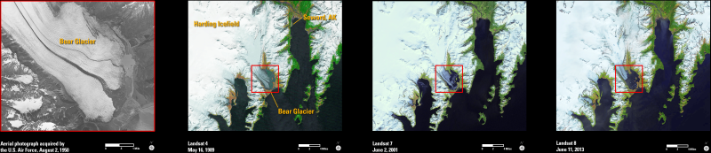
Bear Glacier has been receding dramatically over recent decades, as shown in this series of images. The black and white aerial photograph mosaic was collected in 1950 and shows the glacier extending almost fully across the highlighted region (red outline). The satellite images (color) were acquired by Landsat 4 (1989), Landsat 7 (2001), and Landsat 8 (2013). Taken together, these images show an overall trend of glacial retreat in this area for the 63-year time period.
There are millions of aerial and satellite images held in the USGS archives, which provide important historical and current views of Earth’s changing landscape. These images are public and available for download by anyone for any location worldwide.
This glacier represents one of over 30 glacial outflows for the nearby Harding Icefield, which covers over 700 square miles (1,800 square km). Bear Glacier has been receding dramatically over recent decades, as shown in this series of images. The black and white aerial photograph mosaic was collected in 1950 and shows the glacier covering almost the entire area within the highlighted region (red outline). The satellite images (color) were acquired by Landsat 4 (1989), Landsat 7 (2001), and Landsat 8 (2013). Taken together, these images show an overall trend of glacial retreat in this area for the 63-year time period. There are millions of aerial and satellite images held in the USGS archives, which provide important historical and current views of Earth’s changing landscape. These images are public and available for download by anyone for any location worldwide.