

Massive wildfires scorched nearly 780,000 acres of farm and ranch land in Oklahoma and Kansas in March 2017. The fires started on March 6, and dry conditions and high winds caused the fires to spread rapidly. The series of blazes damaged farms and ranches, and destroyed miles of fences. Many families lost most of their cattle herd, and several homes burned. The fires were considered contained by March 22.
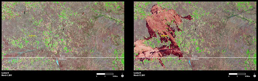
In Clark County, Kansas, the small town of Ashland, located about 40 miles south of Dodge City, had to be evacuated. Fire scars are prominent in Landsat 8’s March 17 image in vivid maroon tones surrounding Ashland, while green blocks of cropland are scattered throughout the image.
Landsat’s shortwave infrared (SWIR) band measures reduced moisture content in soil and vegetation. When combined with its near-infrared (NIR) band, which helps reveal actively growing vegetation, Landsat produces highly accurate images and maps of burned areas. Landsat data can also be used to map the severity of the burn impact on soils and vegetation and to monitor the greenness or recovery of vegetation after the burn.