

On an average day during the fire season, multiple wildfires burn in the western United States. For example, 216 fires were active on July 7, 2017. Firefighters were battling 27 of these fires through ground and air support.
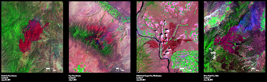
A few of the larger fires in early July were in Arizona, Washington, and Utah. As with many wildfires, Landsat plays an important role in monitoring the spread of these fires and is the primary data source for mapping burn severity after the fires are contained.
In these Landsat images, fresh fire scars are magenta, forest areas are green, cropland is bright green, and grasslands are indicated by duller green and pink hues. Landsat’s shortwave infrared (SWIR), near-infrared (NIR), and red bands combine to provide an accurate distinction between burned and unburned vegetation.
The fires shown here started in mid- to late June and are all in steep, rugged terrain, which makes fighting the blazes difficult. The largest of these four fires is the Brian Head Fire in southwestern Utah, which has consumed more than 71,000 acres.
Landsat 7 and 8 acquisitions help scientists continue to monitor the numerous wildfires in the West. They provide valuable data that assist land managers in understanding the impacts of fires and the need for resource rehabilitation and hazard mitigation.