

Hawaii’s Volcanoes National Park reminds humanity that no matter how much it alters the face of the Earth to meet its needs, it has no control when nature decides to unleash its awesome, eruptive powers.
Though the park celebrates its 100th anniversary on August 1, 2016, its main attractions—Kilauea and Mauna Loa volcanoes—have been adding to the land mass of Hawaii’s “Big Island” for at least 400,000 years. That expansion continues today as bright molten lava from Kilauea flows downslope across the coastal plain on its south flank, spilling over a cliff on its way to a steamy transformation to hard rock in the Pacific Ocean.
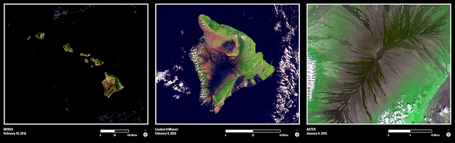
The Operational Land Imager from Landsat 8, as well as NASA’s Advanced Spaceborne Thermal Emission and Reflection Radiometer (ASTER) and Moderate Resolution Imaging Spectroradiometer (MODIS) sensors, show that volcanic influence in several ways. MODIS captures the 1,700-mile stretch of the Hawaiian Islands that began to emerge from volcanic eruptions during the Quaternary Period beginning 2.588 million years ago. A mosaic of Landsat images from October 2015 and February 2016 reveals the extent of Kilauea’s and Mauna Loa’s presence on the big island of Hawaii, and ASTER zooms in even closer on the lava flows and tubes that channel descending lavas from the summit craters and fissure vents.
Even now, in this year of centennial celebrations for both Hawaii Volcanoes National Park and the National Park Service, imagery from sensors such as these will continue to show change with time. Kilauea and Mauna Loa are two of the world’s most active volcanoes. They will be adding land mass to the “Big Island" for years to come.