

When it comes to forest loss on a global scale, Cambodia is notable for how rapidly its forests are being cleared.
Among countries with accelerated rates of deforestation—Sierra Leone, Madagascar, Uruguay, and Paraguay among them—Cambodia ranks above them all with an annual loss of 14.4 percent of its forests between 2001 and 2014, according to researchers at the University of Maryland, who used Landsat data to track their rates. In that time period, Cambodia lost 5,560 square miles of forests.
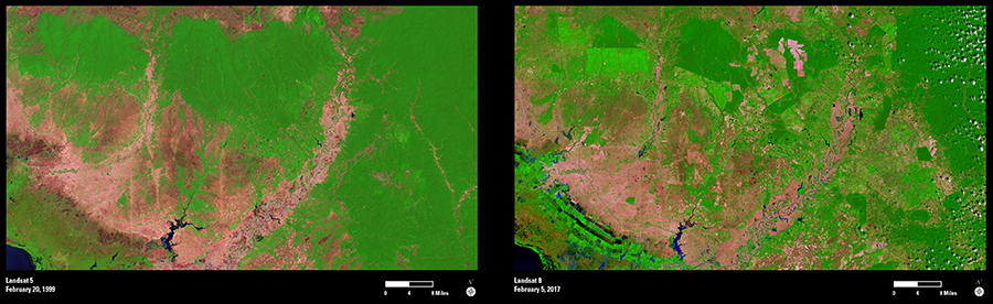
That loss is easily seen in these Landsat images. The Landsat 5 image captured in 1999 (left) shows vast dark green forest among a mountainous area of Cambodia. The 2017 image acquired by Landsat 8 (right) reveals areas where forest has been clear-cut. The bright green landscapes in the lower left interspersed with darker blocks are crops. The pinkish-tan areas are old, small-plot agricultural areas, and the bright green rectangles (top left) are agroforestry areas where rubber or oil palm plantations have emerged.
Working with Landsat data and other economic datasets, researchers at the University of Maryland have demonstrated that changes in global rubber prices and a surge in land-concession deals have helped accelerate Cambodia’s rate of deforestation. The Cambodian government leases concession lands to domestic and foreign investors for agriculture, timber production, and other uses.