

Landsat 8’s shortwave infrared (SWIR) band is useful in viewing recent eruptions at Erta Ale volcano in northern Ethiopia near the Eritrea border. The volcano’s name means “smoking mountain,” and its southernmost vent is referred to as “the gateway to hell.” Both names acknowledge its long-term volcanic activity since the early 1900s, and the persistent filling and draining of lava lakes within its main crater rim. The lava lakes have been filled most recently since the 1960s.
Like other shield volcanoes, Erta Ale has gentle slopes and a wide base of about 25 miles in diameter. Shield volcanoes do not erupt explosively. Instead, the basaltic lava is very fluid and erupts like fountains in the lava lakes and along fissures, flowing like streams down the sides. Darker streaks in these recently acquired Landsat images are some of the previously erupted, cooled, and solidified lava flows.
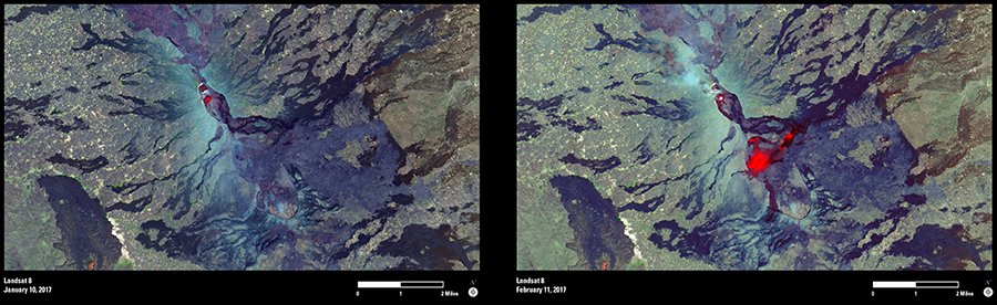
The elliptical summit crater contains several smaller pit craters, and the current lava lake is in one of these. The red spot in the January 10 image is a SWIR signal associated with the location of the most recent lava lake. The February 11 image, however, shows out-gassing of that lava lake and other hot spots on the southeastern slope of the volcano. According to the Global Volcanism Program, new fissures opened on January 21. Landsat’s SWIR signal infers increased temperatures where new lava is either at very shallow depths below the surface or gurgling to the surface.