

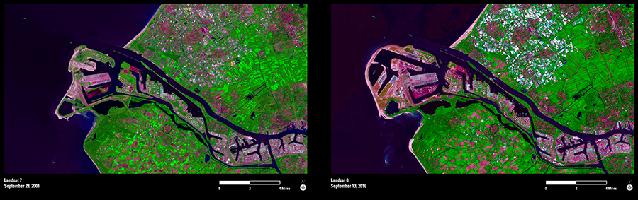
A large infrastructure project has changed the shape of the coastline of the Netherlands while increasing the cargo capacity at Europe’s largest port. This pair of Landsat images spanning 15 years shows the Maasvlakte 2 project, which is an expansion of the Port of Rotterdam. The port provides accessibility for the transportation of cargo from Rotterdam to the rest of Europe.
Land building at Maasvlakte 2 began in 2008. About 230 million cubic meters of sand were dredged from the North Sea to create about 5,000 acres of new land. In addition, 7 million metric tons of stone were used to construct new seawalls.
Commercial cargo operations at the new Maasvlakte 2 facility began in December 2014. Its terminals currently can hold 2.7 million individual 20-foot shipping containers. There is more space for terminals to be built on the new land once demand increases, which would increase the port’s cargo handling capacity even more.
The expansion of land resulted in some loss of permanently flooded sandbanks that affected the availability of food for some protected bird species, such as the common scoter, the sandwich tern, and the common tern. However, this loss was compensated for by establishing a protected seabed area south of the Maasvlakte 2 in the Voordelta. Also, three bird resting areas in the seabed were established where boat traffic is restricted. Landsat can help monitor this coast to ensure the positive impact of these protected areas as compensation for the land expansion.