

Gaborone is the capital and largest city in Botswana. Its current residential population is estimated at 250,000 within the city limits (450,000 when including the outlying areas).
Almost all of this urban development has occurred within the last 50 years. Development of initial infrastructure began in 1963, and the city was formally established in 1966 on the eve of Botswana’s independence. Since that time, Gaborone has experienced rapid urban growth. This expansion is expected to continue as economic and commercial entities become further established there.
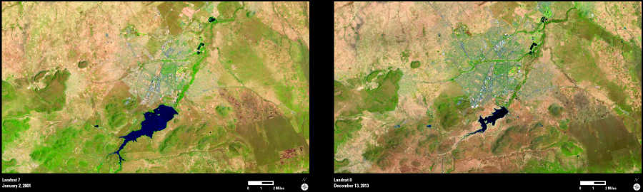
The Gaborone Dam, south of the city, was completed in 1964 and provides critical water supply for the growing city. Within the last decade, the water levels have dropped significantly due to increasing water usage along with climate factors. In the early 2000s, the reservoir was estimated to be 80 percent full; as of December 2013, the water level of the reservoir reached its lowest point since the dam was built, at approximately 13 percent full.
These Landsat images show the city of Gaborone and the surrounding area in 2001 and again in 2013. These images show the urban growth (gray) extending into the landscape in the later image. The images also show the reduction in size of the reservoir over the past 12 years.
As urban populations continue to grow, the changing landscape and water resource management become important issues for community leaders. Landsat imagery provides repetitive views of the Earth’s surface which can help monitor urban growth patterns and other changes to Earth’s resources.