

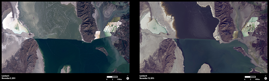
The water level of the north arm of Great Salt Lake, Utah, has reached a record low elevation of 4,191.6 feet, 1 foot below the previous record. Lower snowpack in recent years has lessened the spring runoff flowing into the lake. These Landsat images show the change in water levels between 2011 and 2015.
Great Salt Lake is a closed lake, with no outlet. Since water leaves the lake only through evaporation, it leaves behind its dissolved minerals, making the lake up to 8 times as salty as seawater.
On the right side of these images are evaporation ponds. Water from the north arm is pumped to these ponds. The water evaporates and salt, potassium, and other minerals are extracted.
The lake’s north and south arms are separated by a railroad causeway, the straight line cutting across the images. Limited water circulates between the lake’s north and south arms through the Union Pacific Railroad Causeway breach, but because of the low water levels, the breach is now dry. The result is even saltier water in the north arm.
A USGS article published in late 2015 provides more information about Great Salt Lake.