

As drought conditions continue in the western United States, there is more demand for water for irrigation purposes. Increasing population also increases water demand.
Scientists at the USGS Earth Resources Observation and Science (EROS) Center developed a method to use remote sensing data to quantify water use in the Colorado River Basin. Using Landsat and other ancillary data, including Landsat’s thermal infrared data, scientists created the first ever evapotranspiration (ET) map for the entire basin. ET is water that transpires from plants and evaporates from the ground. It can be used as a measure of water usage. Landsat’s 30-meter resolution allows scientists to estimate ET at the field level.
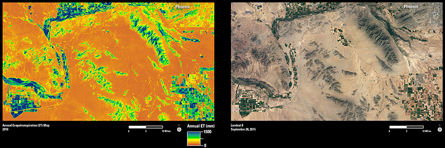
The annual water use map on the left is based on Landsat data collected during 2010. The colors correspond to millimeters (mm) of water lost to the atmosphere through ET. Fields that are green and blue show the highest ET values. Relatively more water has been used on those irrigated fields. Orange hues are areas that have very little ET, such as sparsely vegetated desert. The Landsat 8 image on the right from September 28, 2015, shows many irrigated crop fields just south of Phoenix, Arizona. The image shows the same area as the water use map for comparison.
With the ET map, water managers get information not seen in just the natural color image. This method can be used to create annual water use maps of other regions or even nationwide. Accurate information on water availability and usage is necessary for planning sustainable use of water, particularly in an arid region like the southwestern United States.