

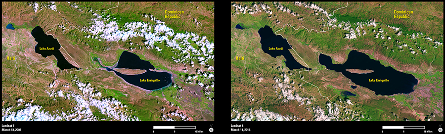
Landsat imagery shows a dramatic change in lakes Azuéi and Enriquillo, inland saltwater lakes on the Caribbean island of Hispaniola that are known for their crocodiles and iguanas.
A Landsat 7 image acquired in March 2002 showed Lake Enriquillo in the Dominican Republic at half the size it is now. In March 2016, Landsat 8 found a growing lake that has engulfed 40,000 acres of farmland and displaced thousands of families. Similarly in Haiti, Lake Azuéi grew 40 percent in that time period, and now stretches even farther across the border into the Dominican Republic.
Lake levels were high 30 years ago, and have fluctuated depending on rainfall and weather patterns. But a consortium of scientists from the United States and Dominican Republic studying this latest phenomenon call a dramatic rise between 2004 and 2009 unprecedented. The Dominican government believes water from the Rio Yaque del Sur, the nation’s second-longest river, is channeling into Lake Enriquillo through agricultural canals after heavy rain events.
Dominican leaders hope damming the Yaque will stymie the growing lakes. Otherwise, they fear the lakes will continue to swallow more farmland as they threaten a fragile ecosystem.
A single Landsat satellite images this area—and any area around the globe—every 16 days, giving scientists a continuous ability to monitor and perhaps mitigate the situation. With the Hispaniola economy already suffering, with Cao Cao and other bird species continuing to lose their nesting habitat, and with crocodiles and endangered iguanas being forced to higher ground to compete with humans and other wildlife, a solution can’t come soon enough.