

A massive wildfire burning near Fort McMurray in Alberta, Canada, fueled by dry conditions and high winds, has destroyed 1,600 structures and forced more than 88,000 people to evacuate the area so far.
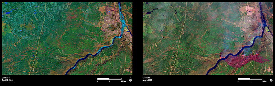
On May 3, 2016, Landsat 8 acquired data of the inferno, which razed neighborhoods within Fort McMurray. Using shortwave infrared (SWIR) and near infrared (NIR) bands to help penetrate clouds and smoke and create false-color imagery, Landsat shows the active fires’ hot spots, which appear orange. Burned area is dark red, and smoke is hazy blue.
Two weeks before the fire started, on April 17, Landsat captured a much quieter scene of Fort McMurray and its surrounding landscape—home to the Athabasca oil sands, the largest known reservoir of crude bitumen in the world.
By May 5, the wildfires had consumed almost 210,000 acres, and forced the largest evacuation on record in Canada.
Forest and fire management officials in Alberta can turn to Landsat for help with post-fire mitigation activities once the blaze is out. Landsat’s infrared sensors are valuable for producing burn-severity maps and other products quickly after images are acquired.