

Remotely sensed imagery of wildfires burning in the Siberia region of Russia shows the complementary possibilities of Landsat 8 and NASA’s ASTER sensor aboard its Terra satellite.
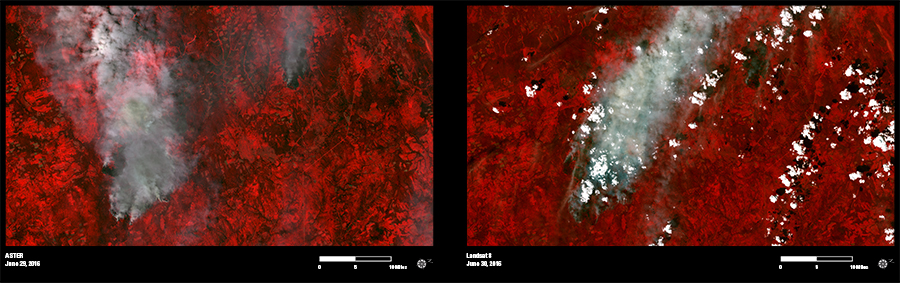
Lightning triggered dozens of forest fires in remote Siberia in late June 2016, burning as much as 7,400 acres, according to Russia’s TASS news agency. Imagery acquired from Terra ASTER on June 29 shows smoke billowing from a small and a large fire, as well as some older burn scars. A day later, when Landsat 8 passed overhead, there was almost no smoke coming from the smaller fire, and a more pronounced scar. Vegetation appears red in the false-color imagery because near infrared (NIR) spectral bands used by both sensors are sensitive to vegetation greenness and were placed in the red position of Red-Green-Blue (RGB) composite images. Burn scars appear a dark brown to black with this band combination.
Though the Terra satellite images the entire Earth every 1 to 2 days, its ASTER instrument with its three separate telescopes only collects data when it is remotely programmed to do so over requested areas of land. That makes it valuable for monitoring disasters. Because Terra’s orbit is similar to that of Landsats 7 and 8—though timed differently—they prove quite complementary when it comes to identifying the impacts of wildfire, flooding, and other events.
Though there is little population in the wildfire area, Russia’s Roscosmos State Corporation for Space Activities asked the International Charter “Space and Major Disasters,” of which USGS and EROS are members, for assistance. That request was granted July 2, giving Russia rapid access to satellite data for assessing the extent of damage and helping with disaster response.