

The expanding coal fields in Wyoming’s Powder River Basin serve as prime examples of Landsat’s ability to monitor land cover change related to industrial growth across the American landscape.
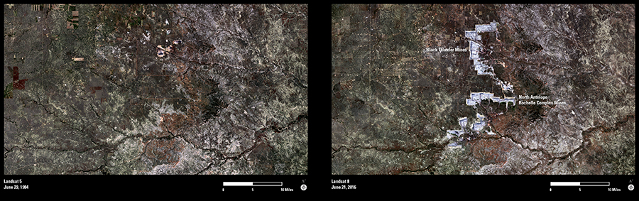
In imagery acquired more than three decades apart, Landsat time-series data illustrate what USGS scientists call a central reality of industrial growth in this country—changing the use of land to increase its economic output. Agriculture remained the main occupation in the basin into the 1970s, until the coal boom took off. The largest U.S. coal mine, the North Antelope Rochelle Mine south of Gillette, WY, opened late in 1983.
The influence of mining is readily apparent in these Landsat images. In 1984, the Landsat 5 scene is largely devoid of open-pit mining signatures. But 32 years later, in 2016, Landsat 8 captures how the Black Thunder Mine and the North Antelope Rochelle Complex have expanded over the last few decades. In 2014, the two mines produced 22 percent of the nation’s coal supply.
USGS officials estimate that mines in the Powder River Basin generally have less than 20 years of economically recoverable coal remaining. Once they end operations, coal mining companies are required by law to reclaim the land, a requirement that Landsat can help verify in the decades to come.