

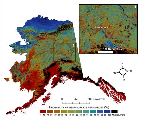
Near-surface permafrost in Alaska is in danger of degrading with projected warmer conditions. Detailed information is needed to adequately monitor permafrost, but previous modeling of permafrost properties has typically been done at coarse resolution. A new study, led by the USGS Earth Resources Observation and Science (EROS) Center, developed the first medium-resolution (30-m) map of near-surface (within 1 m) permafrost for all of mainland Alaska.
Researchers used models to project permafrost degradation in the future based on various climate scenarios described in the Intergovernmental Panel on Climate Change (IPCC). Projections indicate that climate impacts (excluding fire impacts) will cause a decrease in near-surface permafrost of 16 to 24 percent by the end of the 21st century. Predictions of permafrost degradation were most pronounced for central Alaska, where permafrost temperatures typically hover around the melting point of 0°C.
The colors on this map indicate the probability that there is near-surface permafrost currently. Red and orange shades are areas with a low probability of permafrost, and blue shades are areas with a high probability of permafrost. When comparing the current map to future scenarios, the expectation of degraded permafrost is evident.
The mapping of permafrost distribution across Alaska is important for land-use planning, environmental assessments, and predicting future vegetation and carbon stocks. For more information, see the research article in Remote Sensing of Environment.