

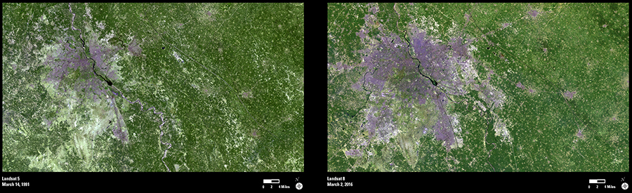
In a world becoming increasingly urbanized, few cities have seen growth as dramatic as that occurring in India’s capital of New Delhi.
These Landsat images from March 1991 and March 2016 show the city and its adjacent suburban areas—known collectively as Delhi. The area’s population ballooned from 9.4 million to 25 million during that period. Only Tokyo is more populated today with a population of 38 million. The United Nation’s Report on World Urbanization projects that Delhi will be at 37 million residents by 2030.
Landsat can be a valuable tool in monitoring urban growth and its impact on the environment. Adjacent forests and agricultural fields converted to streets, parking lots, and rooftops can affect wildlife habitat. Rainfall blocked by impervious surfaces from soaking into the soil can pool and increase local flooding. Chemicals present on the pavement at the time of rain can be carried away with runoff, reducing water quality and threatening aquatic ecosystems downstream.
All are important considerations—in Delhi or any area undergoing significant growth—when it comes to discussions about urban planning. From a regional standpoint at least, and from an environmental one, Landsat is an important part of that conversation.