

In the United States, barrier beaches and spits line up along nearly a quarter of the country’s coasts, mostly facing the Atlantic Ocean and Gulf of Mexico. Spits are like islands that connect to a mainland at one end.
These barrier systems protect their adjacent mainlands from the full fury of ocean wind and wave energy. They promote critical marsh and wetland habitats. They are living landscapes that grow, shrink, and migrate over time.
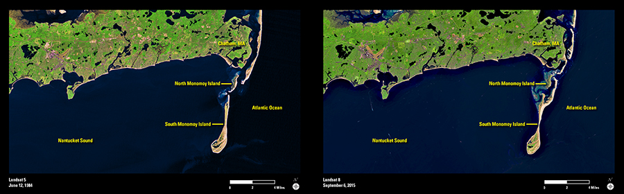
These images of the southeastern elbow of Cape Cod capture the impact of natural forces that have raised up, shifted, and torn down the Nauset-Monomoy coastal barrier system. In the June 1984 scene acquired by Landsat 5, an unbroken barrier spit protects the Atlantic-facing coast of Chatham, MA, and its harbor. South of the mainland, North and South Monomoy Islands stand apart from each other and the coast.
Thirty-one years later, Landsat 8 reveals a landscape reshaped by the natural ebb and flow of waves, currents, winds, and tides. The changes are both subtle and substantial. Storms have breached the barrier spit in several places. By September 2015, the Monomoy islands have grown together. At the same time, waters around North Monomoy are shallower with sandbars and shoals closer to the water surface.
Time and the forces of nature will continue this reshaping of the barrier system. As they do, Landsat’s continuous monitoring will be there to document it.