

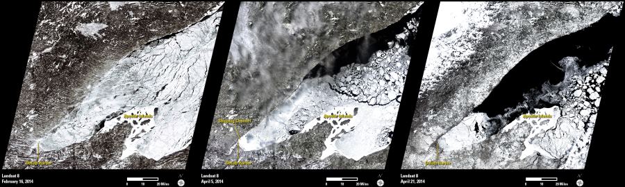
The extreme cold of the 2013-2014 winter season created historic ice cover on the North American Great Lakes and much slower than normal spring melt. The persistent and widespread ice has affected shipping transportation throughout the Great Lakes region. At one point, the Lake Superior ice cover was estimated to be nearly 95% with an average thickness of 22.6 centimeters (8.9 inches). Pressure ridges and ice motion can also cause plates of ice to buckle and stack, creating local ridges up to 1.5 meters (5 feet) thick in some places. Even though the ice has now started to melt, some areas of this year’s ice cover could last into June.
The abnormal thickness and extent of this year’s ice cover caused challenges to the ice breakers that allow shipping to and from ports such as Duluth Harbor. When cutting through very thick ice, it can take many hours to go a very short distance. At one point, as many as 70 ships were awaiting entry into Lake Superior, and the ships were being grouped together as escorted convoys to maximize ice-breaking efforts and allow safe passage.
These three Landsat 8 ”natural-color” (3-band composite) images show the Lake Superior area north of Duluth, Minnesota, in February and April 2014. The first image (February 16) shows the ice cover near its maximum. The second image (April 5) shows reduced ice coverage, along with an ice breaker channel that was created to allow ships to enter Duluth Harbor. The third image shows the remaining ice cover as of April 21.
Landsat imagery provides a consistent and repetitive view of the Earth’s surface and can be used to help monitor changing conditions over time.