Congratulations, you completed the game!
Total Attempts:
Total Time:
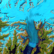
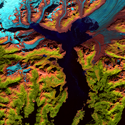
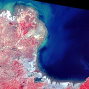
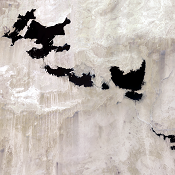
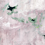
Columbia Glacier, Alaska, USA
Since 1980, the terminus of Columbia Glacier has retreated 20 kilometers, making it one of the most rapidly changing glaciers in the world. A 300-meter deep fjord now replaces the portion of the valley once occupied by the glacier.
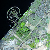
Dubai, United Arab Emirates
As Dubai expands, roads, buildings, and irrigated fields spread out over the desert. But the most prominent project in Dubai, and an impressive engineering feat, is the artificial islands built off its coast. The islands were built from sand dredged from the sea floor.
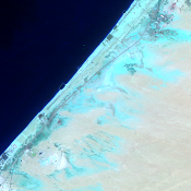
Huang He Delta, China
China’s second longest river, the sediment-choked Huang He (Yellow River), is one of the muddiest rivers on earth. The sediments it carries are deposited at the river’s mouth, creating an ever-changing delta.
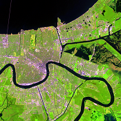
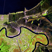
Hurricane Katrina, New Orleans, Louisiana, USA
Hurricane Katrina was one of the most intense and costliest hurricanes to hit the United States. It made landfall the morning of August 29, 2005, as a strong category 3 storm with sustained winds of 125 miles per hour. These Landsat images show the region of storm damage. The flooded areas are dark, giving the city a bruised appearance.
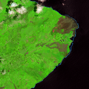
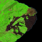
Kīlauea, Hawaii, USA
In 2018, Hawaii was in the news as fresh lava covered 13.7 square miles (35.5 km2) of the eastern tip of the Big Island. The lava flows were from Kīlauea, one of the world’s most active volcanoes. This eruptive event started April 30, 2018, and ended on August 4, 2018.
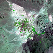
Las Vegas, Nevada, USA
Between 1972 and 2020, the population of Las Vegas grew from 273,000 to over 2.2 million. Spurred by expansion of the gaming and tourism industries, Las Vegas is one of the fastest growing metropolitan areas in the United States. The urban growth is steadily infringing on the arid ecosystems surrounding the city.
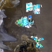
Salar de Atacama, Chile
This desolate salt flat is one of the world’s largest sources of lithium, a key ingredient in rechargeable batteries. The rectangular shapes are evaporation ponds, which vary in color because of varying amounts of salts in the water. The brighter ponds contain more concentrated salts, and the deep blue ponds indicate more water content.
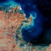
Toshka Project, Egypt
Egypt’s Toshka Project diverted water from the Nile River to the Sahara Desert. The project’s lofty goal was to cultivate a half million acres of land and create a “second Nile Valley.” The Toshka lakes formed in 1998 and reached a peak in size in 2001. Then they promptly began shrinking. But at the end of 2019, they filled up again.
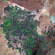
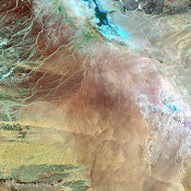
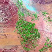
Wadi As-Sirhan Basin, Saudi Arabia
These two images reveal the effects of center-pivot irrigation systems in Saudi Arabia’s desert region known as Wadi As-Sirhan. This landscape has been transformed from wasteland into cropland covered with circular green fields. The fields are watered with groundwater, which in this arid region is a nonrenewable resource.
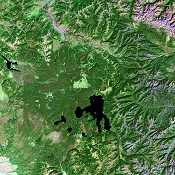
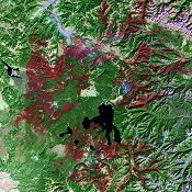
Yellowstone National Park, USA
Dry conditions, along with dry cold fronts that brought lightning but no rain, created extreme fire danger in the summer of 1988. These images show old forest as dark green, occasionally broken up by lighter green grassy meadows or plains. Land just burned is dark red. More than 793,000 acres, or 36% of the park, burned that summer.