
Bureau of Ocean Energy Management (BOEM) and the U.S. Fish and Wildlife Service deployed very-high resolution (VHR), multi-camera sensor arrays on fixed-winged aircraft to develop digital aerial imagery surveys in support of the Atlantic Marine Assessment Program for Protected Species (AMAPPS). In 2021, AMAPPS collected over 1.8 million images from aerial surveys over the Atlantic Ocean Outer Continental Shelf, which includes data from migratory, summer, and winter seasons. The U.S. Geological Survey and the University of California – Berkley are developing annotation databases with the imagery and training machine learning algorithms to automatically detect and classify seabirds, marine mammals, and sea turtles. Automating these steps improves processing efficiency because the data volume precludes manual processing; less than 3% of the imagery contains wildlife. A central imagery database is active and will enable the coordination of data annotation by experts from multiple agencies and institutions to develop species-level classifications. The research team plans to investigate unsupervised data selection and active semi-supervised learning to optimally grow the model with larger-scale data and more wildlife targets of interest. The goal is to gather information on seabird, cetacean, and sea turtle distributions and abundance to inform environmental assessments and impact analyses of offshore energy development.
Recent research has demonstrated the feasibility of identifying whales from Very High Resolution (VHR) satellite imagery using manual and machine learning approaches. BOEM, in collaboration with National Oceanic and Atmospheric Administration (NOAA) Fisheries, the Naval Research Laboratory, and the British Antarctic Survey, has been developing an operational system to detect marine mammals from VHR imagery. Large volumes of imagery from WorldView-3, WorldView-2, and GeoEye satellites have been acquired over seasonal aggregations of North Atlantic right whales, Cook Inlet beluga whales, and bowhead whales. Creating an extensive, standardized dataset of high-quality annotations is a precursor to successful machine learning approaches. Future efforts may include crowdsourcing the identification of whales in imagery via Maxar’s GeoHive platform as well as developing marine mammal detection algorithms and cloud processing workflows with Microsoft AI for Good.
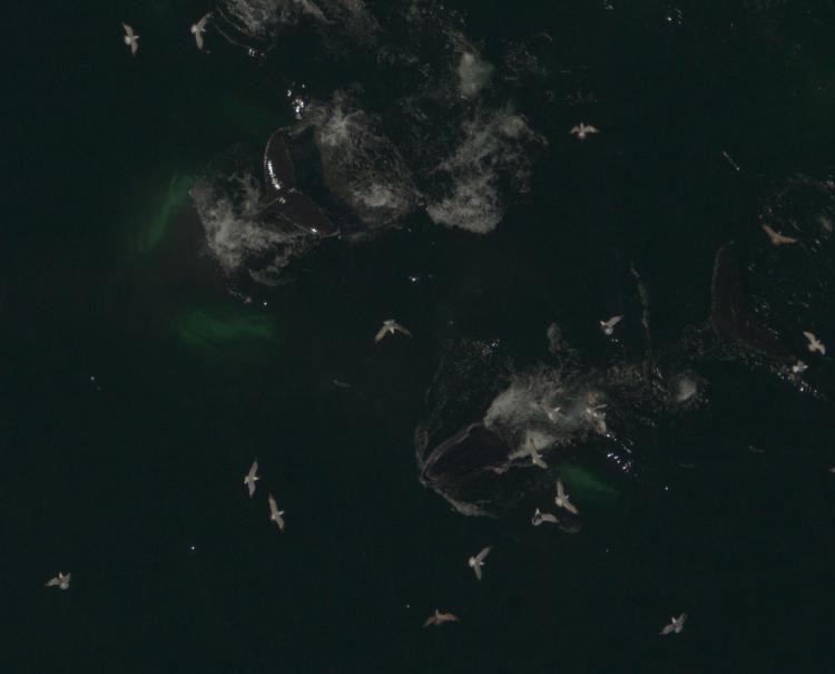
Image of feeding humpback whales and herring gull flock captured by a high-resolution multi-camera sensor array in the Gulf of Maine on an Atlantic Marine Assessment Program for Protected Species (AMAPPS) survey.
Disclaimer: Any use of trade, firm, or product names is for descriptive purposes only and does not imply endorsement by the U.S. Government.