
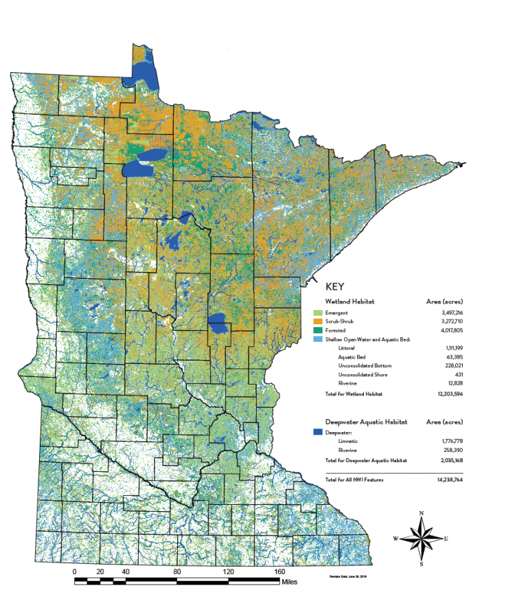
Under the leadership of Dr. Steve Kloiber (steve.kloiber@state.mn.us), the Minnesota Department of Natural Resources (MN DNR) has completed a 10-year effort to update the State’s National Wetlands Inventory (NWI) digital maps using new remote sensing imagery and geospatial technologies to produce a clearer, updated, more accurate picture of Minnesota’s wetlands, lakes, rivers, and streams. In the Land of 10,000 Lakes, the new statewide NWI geographic information system (GIS) dataset reveals there are 14.2 million acres of combined lakes, rivers, streams, and wetlands covering the State of Minnesota. Of this total, 12.2 million acres are wetlands.
Besides showing the location, size, and type of each wetland, the updated map data include information on other wetland characteristics, such as depth, duration, frequency of flooding, and how the wetland is situated in the overall landscape. This information is useful in assessing wetland benefits such as water quality improvement, flood storage, recreation, and carbon storage. The map data are widely used by landowners and local, Tribal, State, and Federal agencies for recreation, land use planning, wetlands permitting, and resource management.
Minnesota was one of the first states originally mapped in the late 1970s and early 1980s using stereo color infrared aerial photography by the U.S. Fish and Wildlife Service, National Wetland Inventory program. The just-completed MN DNR mapping project is the first time the NWI has been updated in Minnesota. The new maps reflect the latest technology in remote sensing and mapping, including high-resolution stereo, spring leaf-off aerial imagery, and lidar data.
The NWI update project was primarily funded by the Minnesota Environment and Natural Resources Trust Fund as recommended by the Legislative-Citizen Commission on Minnesota Resources. Other major partners included the U.S. Fish and Wildlife Service, the University of Minnesota, St. Mary’s University, Ducks Unlimited, and the St. Croix Watershed Research Station.
Minnesota National Wetland Inventory