
The Office of Surface Mining Reclamation and Enforcement (OSMRE) monitors two mine sites in the State of Washington where it is difficult to obtain cloud-free multispectral imagery. OSMRE worked with the Civil Applications Committee to evaluate solutions for overcoming this limitation through high-resolution synthetic aperture radar (SAR). SAR is an active remote sensing system in which the sensor emits a radio wave and then measures the reflected return; it is not hampered by cloud cover. To aid in SAR interpretation, researchers accessed an oblique high-resolution aerial image to help orient new users of SAR imagery to its characteristics. Oblique imagery provides a natural perspective that reveals surface details that can be difficult to discern with nadir orthophotographs. Providing contextual training and familiarization for new users of SAR imagery results in more capabilities for observing areas with persistent cloud cover. Adopting SAR as part of the workflow improves readiness for climatic impacts and emergencies involving OSMRE interests.
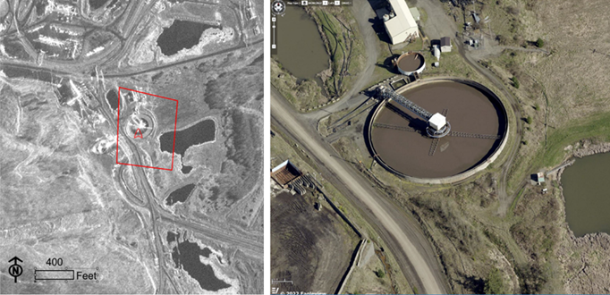
Synthetic aperture radar (SAR) image of a water treatment system collected on November 20, 2021 (left) and oblique high-resolution aerial image collected on April 6, 2022 (right). The red box shows the footprint of the aerial image. The oblique aerial image provides context to features in the SAR image. Because SAR imagery readily reveals surface water extent it is possible to observe that the water level was lower in November 2021 than in April 2022.
Disclaimer: Any use of trade, firm, or product names is for descriptive purposes only and does not imply endorsement by the U.S. Government.