
Caribou (Rangifer tarandus) are an iconic species of the north and an integral component of the natural ecosystem and socioeconomic wellbeing of local communities. Alaska is home to 32 different caribou herds which are identified by females returning to specific calving areas each spring to give birth. The Western Arctic Herd, in northwest Alaska, is the largest and ranges across a staggering 150,000 square-mile area. Sound management of a population that relies on such a massive landscape that encompasses numerous land management boundaries requires an understanding of what areas are used for calving and why.
Caribou monitoring uses location data from GPS collars deployed on a subset of individuals within the herd. These collars transmit the location of the animal at regular intervals and allow biologists to track nearly real-time movement throughout the year. Recent analytical developments permit the detection of calving events from this GPS data alone. With data on when and where a female had a calf from 2010 to 2017, scientists determined how the calving areas for the herd varied each year by comparing how much they overlapped and determined what made this area special. To accomplish this, they relied on remotely sensed data. Researchers used the new interferometric synthetic aperture radar (IFSAR) elevation model, which was collected from airplanes and provides 5-meter resolution data for Alaska to measure elevation, terrain ruggedness, and solar radiation for the analysis. Coarse land cover classifications were included from a composite of classified satellite and aerial photography and included vegetation indices from the MODIS sensor called the Normalized Difference Vegetation Index (NDVI). With NDVI, scientists tested whether caribou were selecting for forage quantity (raw NDVI) or for forage quality (increase in NDVI values across two weeks, indicating new growth).
The team found that calving areas vary from year to year but are centered in a consistent area that matches estimates going back to the 1960s. Additionally, calving areas were characterized by a unique combination of physical factors and, most importantly, were characterized by rapidly greening vegetation at the average time of calving. Results suggest that caribou use memory to guide them back to these general calving areas year after year, at a time when they can access important nutrients after giving birth. Annual variation likely arises as their movements are guided by perception of conditions that year once they arrive. Integrating animal location data with the ever-increasing array of remotely sensed data promises to provide numerous insights into animal ecology that help inform sound management decisions for multiple species.
https://www.nps.gov/im/arcn/caribou.htm
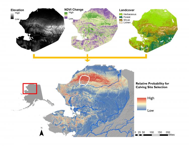
The relative probability of caribou calving (lower plot) within the Western Arctic Herd’s range, Alaska. The upper three plots illustrate the remote sensing products used in the analysis. The white polygon in the lower figure indicates the calving area used every year from 2010 to 2017. For development of layers input to the model, see: https://doi.org/10.3389/fevo.2020.564567