
The U.S. Fish and Wildlife Service (FWS) is using airborne remote sensing technologies to enhance migratory bird surveys to 1) ensure safety of aircrews conducting surveys by allowing flight at higher altitudes, 2) improve the quality of collected population and habitat data by quantifying and minimizing error rates, and 3) increase bird survey efficiency and utility by creating consistent automated processes. The FWS is partnering with the Bureau of Ocean Energy Management (BOEM), U.S. Geological Survey (USGS), academic institutions, and private contractors to accomplish these objectives. Through this collaboration, sensor hardware and software necessary for very high-resolution (centimeter to sub-centimeter), broad field-of-view aerial imaging is being developed to support marine wildlife surveys. Cutting-edge artificial intelligence/machine learning algorithms are being developed to automatically detect seabirds in imagery, and work is underway to automate the process of species classification. To achieve these results efficiently, in-flight processing software will filter images to only those likely to contain seabirds. From there, species will be delineated. Finally, FWS is collaborating with USGS scientists to develop statistical population estimation frameworks that accommodate novel machine learning processes and outputs. Overall, the efficiency gained by these technologies may help inform diverse management decisions, such as identifying wildlife risks in the development of renewable energy in Outer Continental Shelf systems, population monitoring for species of concern, and setting harvest limits for species that utilize these habitats. These novel technologies may continue to be used by FWS in conjunction with other remote sensing products, such as satellite imagery and light detection and ranging (lidar) data, that characterize fish and wildlife habitats, waters, wetlands, and landscapes.
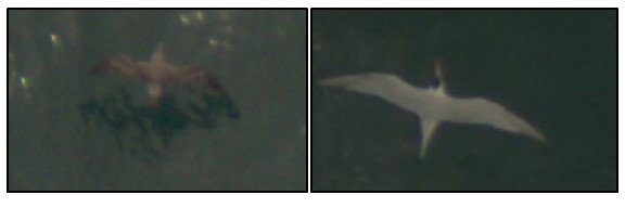
Imagery of Cory's shearwater (left) and a royal tern (right) flying over the Atlantic Ocean as captured from aircraft surveys. U.S. Fish and Wildlife Service uses high-resolution imagery and machine learning to survey migratory seabirds to improve understanding of their abundance and distribution.
Disclaimer: Any use of trade, firm, or product names is for descriptive purposes only and does not imply endorsement by the U.S. Government.