
The U.S. Environmental Protection Agency (EPA) estimates that there are over 2.3 million onshore abandoned oil and gas wells. A well is considered abandoned by State and Federal agencies if there has not been recent oil or gas production, the well head is not properly capped, or there is no responsible operating company. Many oil and gas wells are concentrated in the southwestern United States. According to the U.S. Energy Information Administration, Texas and New Mexico produced 42.7% and 11.3% of the total amount of crude oil in the U.S. in 2021, respectively. Abandoned oil and gas wells release pollutants and greenhouse gasses (GHG) such as methane and carbon dioxide into surrounding soil, water, or air. For agencies and companies considering plugging uncapped wells and remediating land, abandoned wells can be difficult to locate due to inaccurate geospatial data or missing records. To locate abandoned wells more efficiently, deep learning algorithms and a bare earth digital elevation model (DEM) developed from light detection and ranging (lidar) data were used within the U.S. Fish and Wildlife Service (FWS) Southwest Region’s National Wildlife Refuge System. Lidar uses the speed of laser pulses emitted and returned to the sensor to determine the height of objects on the ground. For this study, filtered ground returns were used to create a high-resolution DEM (0.5-meter pixels) and a hillshade map. The U.S. Geological Survey 3D Elevation Program (3DEP) provides quality level 2 lidar (at least 4.0 ground returns per square meter) for much of the Southwest region. The IHS Markit from S&P Global provides frequently updated data on the location and status of oil, gas, and other wells throughout the U.S. These data were used to determine locations containing high densities of oil and gas wells within or near refuges. Digital elevation data were used to develop geomorphology and local relief data layers that were input as predictor variables to convolutional neural network models. Model outputs consisted of well detection polygons and confidence levels to indicate potential abandoned wells, often located in previously unknown and remote locations under overgrown vegetation. These detections appear distinguishable only with the terrain data sourced from lidar because of its ability to capture terrain conditions under vegetation. Future work will involve visiting well locations that were identified by the deep learning algorithms to assess the accuracy of the model. Once confirmed as abandoned, wells can be marked for plugging and remediation, reducing pollution and GHG emissions from public lands.
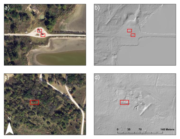
Images of well detections in Hagerman National Wildlife Refuge in Sherman, Texas. a) Well detections on visible shadows of oil well pumpjacks in NAIP imagery and b) the same detection in 0.5-meter lidar-derived hillshade, which shows terrain features associated with well berms and active well infrastructure. A second example c) of a possible abandoned well detected under tree canopy in NAIP imagery paired with d) the same detection in 0.5-meter lidar-derived hillshade, which shows possible well terrain features that can be marked for field inspection. Well detections must be verified in the field as these sites could be associated with other types of land use and ground disturbances.
Disclaimer: Any use of trade, firm, or product names is for descriptive purposes only and does not imply endorsement by the U.S. Government.