
In large river ecosystems the timing, extent, duration, and frequency of floodplain inundation greatly affect the quality of fish and wildlife habitat and the supply of important ecosystem goods and services. Seasonal high flows provide connectivity from the river to the floodplain, and seasonal inundation of the floodplain governs ecosystem structure and function. River regulation and other forms of hydrologic alteration have changed the connectivity of many rivers with their adjacent floodplain, impacting the function of wetlands on the floodplain and, in turn, the mainstem river function. Conservation and management of remaining floodplain resources can be improved through better understanding of the spatial extent and frequency of inundation at scales that are relevant to the species or ecological processes of interest.
Google Earth Engine (GEE) provides cloud-based access to a vast catalog of satellite imagery, including Sentinel-2, which can be used to evaluate the extent of surface water inundation during cloud-free conditions. Relative inundation frequency can be estimated by stacking many images captured under varying hydrologic conditions. Details of this workflow are available in a publication and through a GEE-based Inundation Frequency Explorer App. The web application allows users to analyze inundation conditions anywhere in the conterminous U.S. and customize the results to their own spatial and temporal specifications.
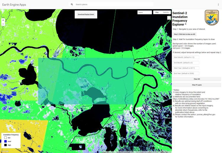
Demonstration of the Inundation Frequency Explorer App results for an area in southern Louisiana.
Disclaimer: Any use of trade, firm, or product names is for descriptive purposes only and does not imply endorsement by the U.S. Government.